File:Lac megantic affected area.png
Jump to navigation
Jump to search

Size of this preview: 800 × 569 pixels. Other resolutions: 320 × 228 pixels | 640 × 455 pixels | 1,024 × 728 pixels | 1,191 × 847 pixels.
Original file (1,191 × 847 pixels, file size: 238 KB, MIME type: image/png)
Captions
Captions
Add a one-line explanation of what this file represents
Summary[edit]
| Description |
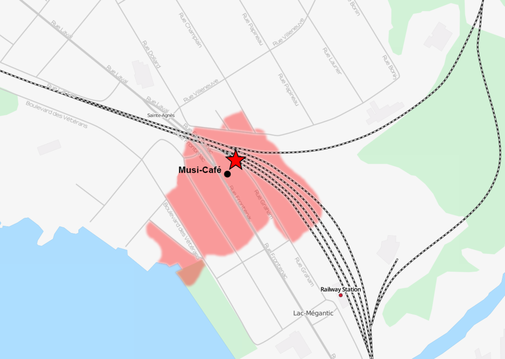
English: Overlays a red area on an openstreetmap section of Lac-Mégantic, based on the star and the national post. Musi-Café location seen here. |
| Date | |
| Source | Made with Paint.NET and using openstreemap |
| Author | Personalmountains |

|
This map image could be re-created using vector graphics as an SVG file. This has several advantages; see Commons:Media for cleanup for more information. If an SVG form of this image is available, please upload it and afterwards replace this template with
{{vector version available|new image name}}.
It is recommended to name the SVG file “Lac megantic affected area.svg”—then the template Vector version available (or Vva) does not need the new image name parameter. |
- Other information
Licensing[edit]
I, the copyright holder of this work, hereby publish it under the following license:
| This file is made available under the Creative Commons CC0 1.0 Universal Public Domain Dedication. | |
| The person who associated a work with this deed has dedicated the work to the public domain by waiving all of their rights to the work worldwide under copyright law, including all related and neighboring rights, to the extent allowed by law. You can copy, modify, distribute and perform the work, even for commercial purposes, all without asking permission.
|
File history
Click on a date/time to view the file as it appeared at that time.
| Date/Time | Thumbnail | Dimensions | User | Comment | |
|---|---|---|---|---|---|
| current | 07:23, 30 June 2021 | | 1,191 × 847 (238 KB) | Isochrone (talk | contribs) | correct café position per request |
| 14:09, 11 July 2013 |  | 1,191 × 847 (196 KB) | Personalmountains (talk | contribs) | Reverted to version as of 13:39, 11 July 2013 | |
| 14:08, 11 July 2013 |  | 1,191 × 847 (196 KB) | Personalmountains (talk | contribs) | trying again, the thumbnail and full size version were still the old one | |
| 13:39, 11 July 2013 |  | 1,191 × 847 (196 KB) | Personalmountains (talk | contribs) | Much smaller affected area with the location of the Musi-Café. | |
| 21:42, 7 July 2013 |  | 1,058 × 817 (236 KB) | Personalmountains (talk | contribs) | More accurate, lighter color, position of the derailment | |
| 19:54, 7 July 2013 |  | 1,058 × 817 (261 KB) | Personalmountains (talk | contribs) | {{subst:Upload marker added by en.wp UW}} {{Information |Description = {{en|Overlays a red area on an openstreetmap section of Lac-Mégantic, based on http://www.radio-canada.ca/regions/estrie/2013/07/07/007-hypothese-accident-megantic.shtml.}} |Source... |
You cannot overwrite this file.
File usage on Commons
The following page uses this file:
File usage on other wikis
The following other wikis use this file:
- Usage on ca.wikipedia.org
- Usage on de.wikipedia.org
- Usage on de.wikinews.org
- Usage on el.wikipedia.org
- Usage on en.wikipedia.org
- Usage on es.wikipedia.org
- Usage on fr.wikipedia.org
- Usage on fr.wikinews.org
- Usage on he.wikipedia.org
- Usage on it.wikipedia.org
- Usage on ja.wikipedia.org
- Usage on nl.wikipedia.org
- Usage on pt.wikipedia.org
- Usage on ro.wikipedia.org
- Usage on ru.wikipedia.org
- Usage on sr.wikinews.org
- Usage on sv.wikipedia.org
- Usage on www.wikidata.org
- Usage on zh.wikipedia.org