File:Map Greece expansion 1832-1947-de.png
Jump to navigation
Jump to search
Size of this preview: 710 × 600 pixels. Other resolutions: 284 × 240 pixels | 569 × 480 pixels | 990 × 836 pixels.
Original file (990 × 836 pixels, file size: 181 KB, MIME type: image/png)
Captions
Captions
Add a one-line explanation of what this file represents
| Description |
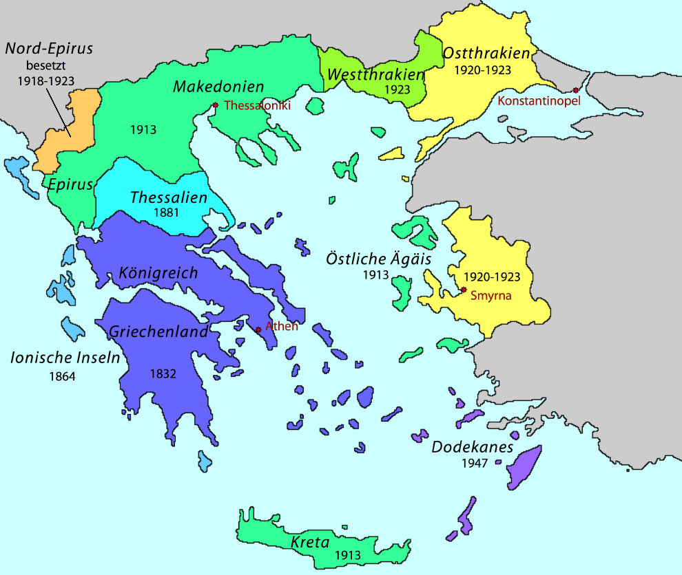
Čeština: Mapa zobrazuje územní expanzi Řeckého království (1832–1947). Dansk: Kort over Grækenlands territoriale udvidelser, 1832-1947. Deutsch: Territoriale Expansion Griechenlands 1832-1947. English: The territorial expansion of Greece, 1832-1947. Español: Mapa de la expansión territorial griega (1832-1947) Euskara: Greziaren lurralde hedapena 1832-1947 bitartean Français : L'expansion territoriale de la Grèce. 1832-1947. Hrvatski: Teritorijalno proširenje Grčke u razdoblju od 1832. do 1947. Italiano: L'espansione territoriale della Grecia dal 1832 al 1947 Magyar: Görögország területi növekedése (1832-1947) Occitan : Evolucions territòrialas de Grècia. Ελληνικά: Η εδαφική επέκταση της Ελλάδας 1832-1947. Македонски: Територијално проширување на Грција Українська: Територіальна експансія Греції (1832-1947). 日本語: ギリシャ王国の版図拡大 (1832-1947年) 中文: 希腊的领土变迁,1832年-1947年间。 العربية : خريطة تُصوِّر الأراضي التي استولت عليها اليونان مُنذُ سنة 1832م حين استقلالها عن الدولة العُثمانيَّة، وُصولًا إلى سنة 1947م |
||||||||
| Date | |||||||||
| Source | Own work (adaptation of Image:Map Greece expansion 1832-1947-fr.svg, GFDL). | ||||||||
| Author | Pitichinaccio | ||||||||
| Permission (Reusing this file) |
|
||||||||
| Other versions |
|


File history
Click on a date/time to view the file as it appeared at that time.
| Date/Time | Thumbnail | Dimensions | User | Comment | |
|---|---|---|---|---|---|
| current | 21:48, 10 May 2010 | | 990 × 836 (181 KB) | Ras67 (talk | contribs) | cropped |
| 00:08, 28 February 2007 |  | 1,000 × 850 (189 KB) | Pitichinaccio (talk | contribs) | ||
| 22:45, 27 February 2007 |  | 1,000 × 850 (189 KB) | Pitichinaccio (talk | contribs) | == Summary == {{Information |Description= {{de|Territoriale Expansion Griechenlands 1832-1947}} |Source=Own work (adaptation of Image:Map Greece expansion 1832-1947-fr.svg, GFDL). |Date=2007-02-27 |Author=Pitichinaccio |Permiss |
You cannot overwrite this file.
File usage on Commons
The following 30 pages use this file:
- File:ExpansionofModernGreece.png
- File:Greek history from 1832-ar.png
- File:Greek history from 1832.GIF
- File:Greekhistory-zh-classical.png
- File:Greekhistory el.gif
- File:Grècia - Evolucions territòrialas.png
- File:La expansión territorial de Grecia (1832-1947).PNG
- File:Map Greece Megali Idea (hy).png
- File:Map Greece expansion 1832-1947-HE.svg
- File:Map Greece expansion 1832-1947-ar.svg
- File:Map Greece expansion 1832-1947-cs-2.svg
- File:Map Greece expansion 1832-1947-da.svg
- File:Map Greece expansion 1832-1947-el.svg
- File:Map Greece expansion 1832-1947-en.svg
- File:Map Greece expansion 1832-1947-es.svg
- File:Map Greece expansion 1832-1947-eu.png
- File:Map Greece expansion 1832-1947-fr.svg
- File:Map Greece expansion 1832-1947-he.svg
- File:Map Greece expansion 1832-1947-hr.svg
- File:Map Greece expansion 1832-1947-hu.svg
- File:Map Greece expansion 1832-1947-it.svg
- File:Map Greece expansion 1832-1947-mk.svg
- File:Map Greece expansion 1832-1947-nl.svg
- File:Map Greece expansion 1832-1947-sr.svg
- File:Map Greece expansion 1832-1947-zhcn.svg
- File:Map Greece expansion 1832-1947 ja.svg
- File:Territorial Expansion of Greece from 1832–1947.gif
- File:Επέκταση Ελλάδας 1832-1947.svg
- File:Територіальна експансія Греції в 1832-1947рр.png
- Template:Other versions/Map Greece expansion 1832-1947
.PNG)
.png)
File usage on other wikis
The following other wikis use this file:
- Usage on de.wikipedia.org
- Usage on de.wikibooks.org