File:Scottish independence referendum results.svg
Jump to navigation
Jump to search

Size of this PNG preview of this SVG file: 456 × 600 pixels. Other resolutions: 182 × 240 pixels | 365 × 480 pixels | 584 × 768 pixels | 779 × 1,024 pixels | 1,558 × 2,048 pixels | 1,128 × 1,483 pixels.
Original file (SVG file, nominally 1,128 × 1,483 pixels, file size: 1.65 MB)
Captions
Captions
Add a one-line explanation of what this file represents
Summary[edit]
| Description |
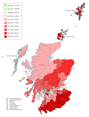
English: Results of the Scottish independence referendum by council area, with strength of vote based on saturation of colour:
Based on File:Scottish council areas 2011.svg by Nilfanion Legend: 55.0-57.5% Yes
52.5-55.0% Yes
50.0-52.5% Yes
50.0-52.5% No
52.5-55.0% No
55.0-57.5% No
57.5-60.0% No
60.0-62.5% No
62.5-65.0% No
65.0-67.5% No |
| Date | |
| Source |
 |
| Author | Brythones |
| SVG development | This W3C-invalid map was created with Adobe Illustrator. |
Licensing[edit]
I, the copyright holder of this work, hereby publish it under the following license:
This file is licensed under the Creative Commons Attribution-Share Alike 4.0 International license.
- You are free:
- to share – to copy, distribute and transmit the work
- to remix – to adapt the work
- Under the following conditions:
- attribution – You must give appropriate credit, provide a link to the license, and indicate if changes were made. You may do so in any reasonable manner, but not in any way that suggests the licensor endorses you or your use.
- share alike – If you remix, transform, or build upon the material, you must distribute your contributions under the same or compatible license as the original.
File history
Click on a date/time to view the file as it appeared at that time.
| Date/Time | Thumbnail | Dimensions | User | Comment | |
|---|---|---|---|---|---|
| current | 08:28, 9 March 2022 | | 1,128 × 1,483 (1.65 MB) | AlloDoon (talk | contribs) | Reverted to version as of 02:20, 9 March 2022 (UTC) |
| 02:25, 9 March 2022 |  | 1,128 × 1,483 (1.66 MB) | AlloDoon (talk | contribs) | General clean-up of map | |
| 02:20, 9 March 2022 |  | 1,128 × 1,483 (1.65 MB) | AlloDoon (talk | contribs) | Updated to Blue-Red scheme for colourblind users to be able to perceive | |
| 20:28, 27 May 2019 |  | 1,128 × 1,483 (2.57 MB) | Renamed user OCfxJKu7j2 (talk | contribs) | Improved version | |
| 15:00, 27 May 2019 |  | 1,128 × 1,483 (2.57 MB) | Renamed user OCfxJKu7j2 (talk | contribs) | Labelled version which is easier to read | |
| 09:02, 3 May 2015 |  | 1,023 × 1,345 (3.2 MB) | Renamed user OCfxJKu7j2 (talk | contribs) | Added scale for ease of use: this scale is used on various other comparable files such as the devolution referendums in Scotland and Wales. | |
| 15:45, 13 November 2014 |  | 1,023 × 1,345 (2.96 MB) | Renamed user OCfxJKu7j2 (talk | contribs) | Better saturation of colours which are in line with the Catalan referendum and 1979 devolution referendum. | |
| 12:02, 19 September 2014 |  | 1,023 × 1,345 (2.93 MB) | Cmglee (talk | contribs) | Adjust opacity to match table values. | |
| 11:27, 19 September 2014 |  | 1,023 × 1,345 (2.93 MB) | Cmglee (talk | contribs) | Fife, Highland and Moray | |
| 04:59, 19 September 2014 |  | 1,023 × 1,345 (2.93 MB) | Sceptre (talk | contribs) | Argyll and Bute, Edinburgh, Aberdeenshire |
You cannot overwrite this file.
File usage on Commons
The following 2 pages use this file:
File usage on other wikis
The following other wikis use this file:
- Usage on ca.wikipedia.org
- Usage on co.wikipedia.org
- Usage on cs.wikipedia.org
- Usage on de.wikipedia.org
- Usage on en.wikipedia.org
- Usage on en.wikibooks.org
- Usage on en.wiktionary.org
- Usage on es.wikinews.org
- Usage on eu.wikipedia.org
- Usage on fr.wikinews.org
- Usage on gl.wikipedia.org
- Usage on hi.wikipedia.org
- Usage on is.wikipedia.org
- Usage on it.wikipedia.org
- Usage on ja.wikipedia.org
- Usage on lt.wikipedia.org
- Usage on pt.wikipedia.org
- Usage on ru.wikinews.org
- Usage on sl.wikipedia.org
- Usage on sv.wikipedia.org
- Usage on th.wikipedia.org
- Usage on tr.wikipedia.org
- Usage on uk.wikipedia.org
- Usage on vi.wikipedia.org
- Usage on www.wikidata.org
- Usage on zh.wikipedia.org