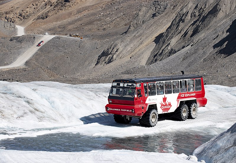
File:'Ice Explorers' Approaching the Athabasca Glacier -- Jasper National Park Alberta September 2019 (49421973251).jpg

Original file (5,489 × 3,787 pixels, file size: 5.94 MB, MIME type: image/jpeg)
Captions
Captions
Summary[edit]
| Description'Ice Explorers' Approaching the Athabasca Glacier -- Jasper National Park Alberta September 2019 (49421973251).jpg |
Per the 'Pursuit Banff Jasper Collection' website: "The Ice Explorers provides all-terrain mobility to transport up to 56 passengers. Their six soft ('low-pressure') tires are massive. These buses can be used to take people both on road and off-road. With the six-wheel drive using a transmission lock-up, the buses can ascend and descend +30 degree grades. They alos have extra large side and top windows that provide greater all-around visibility. Dimensions: Height: 3.86 m (12 ft 8 in) 3.86 m Length: 13.0 m (42 ft 8 in) Width: 3.61 m (11 ft 10 in) Weight: 25,000 kg (55,000 lbs) Tare: 19,500 kg (43,000 lbs) G.V.W.: 25,000 kg (55,000 lbs) Powertrain: Engine -- Three 1980s vehicles: DDA 6V92TA (DDEC), 253 HP All other vehicles, except refurbished units: Detroit Diesel 60 series (DDEC), 250 HP 2012 to 2017 refurbished units: Mercedes-Benz 240 Series (Tier 3), 330 HP 2018-19 and future refurbished units: Mercedes-Benz 4R/6R 1000 series (Tier 4), 280 HP Transmission -- Clark 34000 Series Powershift Allison 3000/4000 series fully automatic with Transmission Retarder (Refurbished Units) Suspension -- Front: Leaf spring Rear: Walking beam Axles -- Rockwell Drive Steer Planetary front; Rockwell Planetary rear Refurbished units: Axletech MX Series Front Drive Steer and RS series single reduction for rear Tires --: Alliance Tires 66 x 43.00 x 25 Brakes -- Air over hydraulic front drums; air rear drums Refurbished units: Air over hydraulic front disks; air rear drums" DSC0147 |
| Date | |
| Source | 'Ice Explorers' Approaching the Athabasca Glacier -- Jasper National Park Alberta September 2019 |
| Author | Ron Cogswell from Arlington, Virginia, USA |
| Camera location | 52° 12′ 29.65″ N, 117° 14′ 09.16″ W | View this and other nearby images on: OpenStreetMap |
|---|
Licensing[edit]
- You are free:
- to share – to copy, distribute and transmit the work
- to remix – to adapt the work
- Under the following conditions:
- attribution – You must give appropriate credit, provide a link to the license, and indicate if changes were made. You may do so in any reasonable manner, but not in any way that suggests the licensor endorses you or your use.
| This image was originally posted to Flickr by Ron Cogswell at https://flickr.com/photos/22711505@N05/49421973251. It was reviewed on 29 July 2020 by FlickreviewR 2 and was confirmed to be licensed under the terms of the cc-by-2.0. |
29 July 2020
File history
Click on a date/time to view the file as it appeared at that time.
| Date/Time | Thumbnail | Dimensions | User | Comment | |
|---|---|---|---|---|---|
| current | 06:52, 29 July 2020 |  | 5,489 × 3,787 (5.94 MB) | TaurusEmerald (talk | contribs) | Transferred from Flickr via #flickr2commons |
You cannot overwrite this file.
File usage on Commons
There are no pages that use this file.
Metadata
This file contains additional information such as Exif metadata which may have been added by the digital camera, scanner, or software program used to create or digitize it. If the file has been modified from its original state, some details such as the timestamp may not fully reflect those of the original file. The timestamp is only as accurate as the clock in the camera, and it may be completely wrong.
| Camera manufacturer | NIKON CORPORATION |
|---|---|
| Camera model | NIKON D5500 |
| Exposure time | 1/500 sec (0.002) |
| F-number | f/11 |
| ISO speed rating | 220 |
| Date and time of data generation | 14:20, 6 September 2019 |
| Lens focal length | 86 mm |
| Orientation | Normal |
| Horizontal resolution | 240 dpi |
| Vertical resolution | 240 dpi |
| Software used | Adobe Photoshop 21.0 (Macintosh) |
| File change date and time | 17:57, 20 January 2020 |
| Exposure Program | Not defined |
| Exif version | 2.31 |
| Date and time of digitizing | 14:20, 6 September 2019 |
| APEX shutter speed | 8.965784 |
| APEX aperture | 6.918863 |
| APEX exposure bias | 0 |
| Maximum land aperture | 4.9 APEX (f/5.46) |
| Metering mode | Pattern |
| Light source | Unknown |
| Flash | Flash did not fire, compulsory flash suppression |
| DateTime subseconds | 13 |
| DateTimeOriginal subseconds | 13 |
| DateTimeDigitized subseconds | 13 |
| Color space | Uncalibrated |
| Focal plane X resolution | 2,558.641204834 |
| Focal plane Y resolution | 2,558.641204834 |
| Focal plane resolution unit | 3 |
| Sensing method | One-chip color area sensor |
| File source | Digital still camera |
| Scene type | A directly photographed image |
| Custom image processing | Normal process |
| Exposure mode | Auto exposure |
| White balance | Auto white balance |
| Digital zoom ratio | 1 |
| Focal length in 35 mm film | 129 mm |
| Scene capture type | Landscape |
| Scene control | None |
| Contrast | Normal |
| Saturation | Normal |
| Sharpness | Normal |
| Subject distance range | Unknown |
| Serial number of camera | 2582548 |
| Lens used | 18.0-300.0 mm f/3.5-6.3 |
| Rating (out of 5) | 0 |
| Date metadata was last modified | 12:57, 20 January 2020 |
| Unique ID of original document | 71DE307F9FE077F4814F82B1712A69F5 |