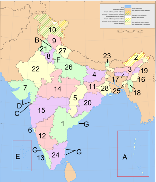
File:Ŝtatoj de Barato (numerigitaj).png
From Wikimedia Commons, the free media repository
Jump to navigation
Jump to search

Size of this preview: 513 × 599 pixels. Other resolutions: 205 × 240 pixels | 411 × 480 pixels | 657 × 768 pixels | 876 × 1,024 pixels | 1,602 × 1,872 pixels.
Original file (1,602 × 1,872 pixels, file size: 547 KB, MIME type: image/png)
File information
Structured data
Captions
Captions
Add a one-line explanation of what this file represents
| DescriptionŜtatoj de Barato (numerigitaj).png |
English: map of the states and territories of India, numbered, labelled in Esperanto
Esperanto: mapo de la Ŝtatoj kaj Teritorioj de Barato, numerigitaj, priskribo en Esperanto |
| Date | adaptation 2010-11-29 |
| Source | adaptation of India-states-numbered.svg and of Ŝtatoj de Barato (numerigitaj).svg |
| Author | Based on Planemad's India map en.jpeg |
| Other versions | India-states-numbered.svg (in English / angle) and Ŝtatoj de Barato (numerigitaj).svg |
Esperanto: Subŝtatoj kaj teritorioj de Barato[edit]
Subŝtatoj:
Uniaj teritorioj:
|
File history
Click on a date/time to view the file as it appeared at that time.
| Date/Time | Thumbnail | Dimensions | User | Comment | |
|---|---|---|---|---|---|
| current | 07:27, 30 November 2010 |  | 1,602 × 1,872 (547 KB) | ThomasPusch (talk | contribs) | {{Information |Description={{en|map of the states and territories of India, numbered, labelled in Esperanto}} {{eo|mapo de la Ŝtatoj kaj Teritorioj de Barato, numerigitaj, priskribo en Esperanto}} |Source=adaptation of [[:file:India-states-numbered.svg|I |
You cannot overwrite this file.
File usage on Commons
The following page uses this file:
File usage on other wikis
The following other wikis use this file:
- Usage on eo.wikipedia.org