File:Благовещенская пустынь и Медынское городище.jpg
Jump to navigation
Jump to search

Size of this preview: 797 × 600 pixels. Other resolutions: 319 × 240 pixels | 638 × 480 pixels | 1,021 × 768 pixels | 1,251 × 941 pixels.
Original file (1,251 × 941 pixels, file size: 395 KB, MIME type: image/jpeg)
Captions
Captions
Add a one-line explanation of what this file represents
Summary[edit]
| Description |
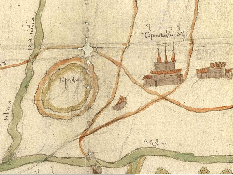
Русский: Ф. 1209. Оп. 77. Ед. хр. 19028 Чертеж земель в окрестностях Медынского городища. Подлинник.
Датировка: XVII в. Документ зафиксировал исторический ландшафт и коммуникации в окрестностях Медынского городища, существовавшие в эпоху позднего Средневековья. Помимо упомянутого городища, на чертеже особо отмечены: Благовещенский монастырь, пустоши Саларево, Ивачево, Цвиленево, Челюсткино, Коркодиново, Огашино и Черневка, речки Медынка, Гомышовка и Каменка, межевые грани земельных угодий. Историческая справка: Выполненный в красках чертеж окрестностей Медынского городища был создан в Поместном приказе во второй половине XVII в. в ходе разбирательства одного из дел, которое к настоящему времени не сохранилось. |
| Date | |
| Source | http://rgada.info/kueh/index.php?page=4&Sk=30&T1= |
| Author | Не установлен |
Licensing[edit]
|
This work is in the public domain in its country of origin and other countries and areas where the copyright term is the author's life plus 70 years or fewer. This work is in the public domain in the United States because it was published (or registered with the U.S. Copyright Office) before January 1, 1929. | |
| This file has been identified as being free of known restrictions under copyright law, including all related and neighboring rights. | |
File history
Click on a date/time to view the file as it appeared at that time.
| Date/Time | Thumbnail | Dimensions | User | Comment | |
|---|---|---|---|---|---|
| current | 06:21, 25 August 2017 | | 1,251 × 941 (395 KB) | VickRomanoff (talk | contribs) | User created page with UploadWizard |
You cannot overwrite this file.
File usage on Commons
There are no pages that use this file.
File usage on other wikis
The following other wikis use this file:
- Usage on ru.wikipedia.org