File:תל אביב - יד אליהו - (ע"ש אליהו גולומב) - אדמות זאבלאווי ליד תל אביב-JNF025425.jpeg
תל_אביב_-_יד_אליהו_-_(ע"ש_אליהו_גולומב)_-_אדמות_זאבלאווי_ליד_תל_אביב-JNF025425.jpeg (600 × 392 pixels, file size: 40 KB, MIME type: image/jpeg)
Captions
Captions
Summary[edit]
| Photographer |
עברית: לזר דינר |
|||
| Description |
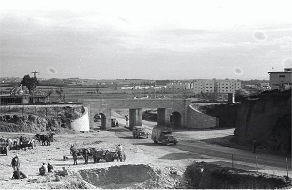
Deutsch: Blick 1947 aus dem Ortsteil Naweh Scha'anan (נָוֶה שַׁאֲנָן; im Rücken des Betrachters), ostwärts auf den Gescher Rosch Pinnah (גֶּשֶׁר רֹאשׁ פִּנָּה; Plene: גשר ראש פינה), die Bahnbrücke, die den Rechov Rosch Pinnah (רְחוֹב רֹאשׁ פִּנָּה) überspannte, auf das unbebaute Nordostende dieser Straße in neue Viertel, wie das im Bau befindliche Jad Eliahu. Der Gescher Rosch Pinnah war eine Brücke der Bahnstrecke Jaffa–Jerusalem (J&J-Linie), die in disem Abschnitt in einer weiten Kurve zwischen ihrem Verlauf in Nordwest-Südost-Richtung parallel zum Rechov ha-Rakkevet und demjenigen in Nord-Süd-Richtung parallel zum Rechov he-Charasch (רְחוֹב הֶחָרָשׁ) wechselte. Der Bahndamm bildete die nördliche und östliche Begrenzung Naweh Scha'anans, das 1921-23 entstand. Der Rechov Rosh Pinnah ist eine Hauptstraße im Ortsteil Naweh Scha'anan (נָוֶה שַׁאֲנָן), die in Südwest-Nordost-Richtung verläuft. Die Bahnstrecke wurde in diesem Abschnitt 1970 stillgelegt und die Brücke 1971 abgebrochen, der Bahndamm abgetragen, die so gewonnene Fläche später in die verbreiterten Straßen Rechov ha-Rakkevet und Rechov he-Charasch (der zugleich die Fernstraße Kvisch 2 bildet) einbezogen. Die Brücke lag im heute weiten Raum der Kreuzung von Rechov ha-Rakkevet (von Nordwest), Rechov ha-Masger (von Nord), Rechov La Guardia (von Ost), Rechov he-Charasch (von Süd), Rechov Levandah (von Süd-Südwest) und Rechov Rosch Pinnah (von Südwest). Das kurze, unbebaute Ende des Rechov Rosch Pinnah, das nordöstlich der Brücke lag, ist im Raum der Kreuzung aufgegangen.
Nederlands: Toegangsweg tot Tel Aviv met autoverkeer en het gezicht op een spoorwegviaduct en de stadsrand.
עברית: תל אביב - יד אליהו - (ע"ש אליהו גולומב) - אדמות זאבלאווי ליד תל אביב
English: The Gesher Rosh Pinnah (גֶּשֶׁר רֹאשׁ פִּנָּה) was a bridge by means of which the Jaffa–Jerusalem Railway (J&J line) crossed the Reḥov Rosh Pinnah (רְחוֹב רֹאשׁ פִּנָּה). The bridge lay in a wide curve of the J&J line, by which the railway line changed between its northwest-southeast course parallel to Reḥov ha-Rakkevet and its north-south course parallel to Reḥov he-Kharash (רְחוֹב הֶחָרָשׁ). The rail causeway formed the northern and eastern border to Naveh Sha'anan (נָוֶה שַׁאֲנָן), a neighbourhood of Tel Aviv founded in 1921/1923. The Reḥov Rosh Pinnah is a main street of Naveh Sha'anan, which runs in the southwest-northeast direction. In this photo from 1947 the view is directed eastwards into today's Reḥov La Guardia with the new neighbourhood of Yad Eliahu under construction. Naveh Sha'anan is behind the viewer. The railway line was shut down in this section in 1970 and the bridge demolished in 1971, the railway causeway was removed, the area thus gained was later converted into the widened streets Reḥov ha-Rakkevet and Reḥov he-Kharash (which forms also the trunk road Kvish 2). The bridge lay in what is now the wide area of the intersection of Reḥov ha-Rakkevet (from the north-west), Reḥov ha-Masger (from the north), Reḥov La Guardia (from the east), Reḥov he-Kharash (from the south), Reḥov Levandah (from the south-southwest) and Reḥov Rosh Pinnah (from the south-west). The short, undeveloped end of the Reḥov Rosh Pinnah, which lay north-east of the bridge here partially in view behinde the bridge, disappeared in today's wide area of the crossroads. |
|||
| Date | 1 December 1947 | |||
| Collection | ||||
| Current location |
Jewish National Fund photo archive |
|||
| Source |
|
|||
| JNF file name | 025425 |


_-_%D7%90%D7%93%D7%9E%D7%95%D7%AA_%D7%96%D7%90%D7%91%D7%9C%D7%90%D7%95%D7%95%D7%99_%D7%9C%D7%99%D7%93_%D7%AA%D7%9C_%D7%90%D7%91%D7%99%D7%91-JNF025425.jpeg&action=edit§ion=1)

|
The upload of this file was supported by Wikimedia Israel.
To see other files made with the support of Wikimedia Israel, please see the category Supported by Wikimedia Israel. |
Licensing[edit]
_-_%D7%90%D7%93%D7%9E%D7%95%D7%AA_%D7%96%D7%90%D7%91%D7%9C%D7%90%D7%95%D7%95%D7%99_%D7%9C%D7%99%D7%93_%D7%AA%D7%9C_%D7%90%D7%91%D7%99%D7%91-JNF025425.jpeg&action=edit§ion=2)
This work or image is now in the public domain because its term of copyright has expired in Israel (details). According to Israel's copyright statute from 2007 (translation), a work is released to the public domain on 1 January of the 71st year after the author's death (paragraph 38 of the 2007 statute) with the following exceptions:
|
 |
File history
Click on a date/time to view the file as it appeared at that time.
| Date/Time | Thumbnail | Dimensions | User | Comment | |
|---|---|---|---|---|---|
| current | 08:55, 9 April 2018 | | 600 × 392 (40 KB) | Wmilbot (talk | contribs) | uploaded by wmilbot |
You cannot overwrite this file.
File usage on Commons
The following 2 pages use this file:
_-_%D7%90%D7%93%D7%9E%D7%95%D7%AA_%D7%96%D7%90%D7%91%D7%9C%D7%90%D7%95%D7%95%D7%99_%D7%9C%D7%99%D7%93_%D7%AA%D7%9C_%D7%90%D7%91%D7%99%D7%91-JNF025425.jpeg)
_-_אדמות_זאבלאווי_ליד_תל_אביב-JNF025425.jpeg&oldid=746489627)