File:00 1706 South America. - El Alto International Airport (La Paz).jpg
Jump to navigation
Jump to search

Size of this preview: 800 × 533 pixels. Other resolutions: 320 × 213 pixels | 640 × 427 pixels | 1,024 × 683 pixels | 1,280 × 853 pixels | 2,560 × 1,707 pixels | 3,300 × 2,200 pixels.
Original file (3,300 × 2,200 pixels, file size: 5.21 MB, MIME type: image/jpeg)
Captions
Captions
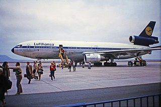
La Paz - El Alto Airport Bolivia
Summary[edit]
.jpg&action=edit§ion=1)
| Description |
Deutsch: La Paz, Bolivien: der internationale Flughafen El Alto liegt auf 4.061 Meter über N.N.
Simple English: La Paz, Bolivia: El Alto International Airport is located at 4,061 meters above sea level. |
| Date | |
| Source | Own work |
| Author | W. Bulach |
| Camera location | | View this and other nearby images on: OpenStreetMap |
|---|
.jpg¶ms=-16.508044_N_-068.176911_E_globe:Earth_type:camera__&language=en)
Licensing[edit]
.jpg&action=edit§ion=2)
I, the copyright holder of this work, hereby publish it under the following license:
This file is licensed under the Creative Commons Attribution-Share Alike 4.0 International license.
- You are free:
- to share – to copy, distribute and transmit the work
- to remix – to adapt the work
- Under the following conditions:
- attribution – You must give appropriate credit, provide a link to the license, and indicate if changes were made. You may do so in any reasonable manner, but not in any way that suggests the licensor endorses you or your use.
- share alike – If you remix, transform, or build upon the material, you must distribute your contributions under the same or compatible license as the original.
Die Aufnahme entstand im Jahre 1987 mit einem Diapositivfilm. Das Dia wurde 2015 durch Abfotografieren miitels eines Slide DUPLICATOR in das JPEG-Format umgewandelt.
File history
Click on a date/time to view the file as it appeared at that time.
| Date/Time | Thumbnail | Dimensions | User | Comment | |
|---|---|---|---|---|---|
| current | 10:57, 24 December 2018 | | 3,300 × 2,200 (5.21 MB) | W. Bulach (talk | contribs) | User created page with UploadWizard |
You cannot overwrite this file.
File usage on Commons
The following page uses this file:
File usage on other wikis
The following other wikis use this file:
- Usage on es.wikipedia.org
- Usage on www.wikidata.org
.jpg&oldid=735463738)