File:11 13th century Asia Minor Turkish Invasions.Ellinika.png

Original file (1,232 × 599 pixels, file size: 664 KB, MIME type: image/png)
Captions
Captions
Summary[edit]
| Description |
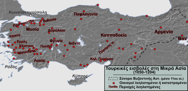
Ελληνικά: Λεηλασίες και καταστροφές οικισμών στη Μικρά Ασία ως αποτέλεσμα του πρώτου κύματος των εισβολών τουρκικών φύλων (περ. 1050-1204) |
| Date | |
| Source |
Own work, data taken from: Eastern Anatolia: Settlements sacked or destroyed: Caesarea, Edessa, Melitene, Sebastea, Arabisus, Albistan, Kaisum, Nisibis, Gargar, Ani, Artze, Zorinak Regions pillaged: Cappadocia, Pyramus, Armenia, Lake Van Northern Anatolia: Settlements sacked or destroyed: Sinope, Trebizond, Neocaesaria, Castamon, Gangra Southern Anatolia: Settlements sacked or destroyed: Seleucia, Mopsouestia, Adana, Corycus, Precana Regions pillaged: Piramus Valley Central Anatolia: Settlements sacked or destroyed: Iconium, Ankara, Coloneia Archelais, Laodiceia Combusta
|
| Author | Alexikoua |
| Other versions |
 |
Licensing[edit]
- You are free:
- to share – to copy, distribute and transmit the work
- to remix – to adapt the work
- Under the following conditions:
- attribution – You must give appropriate credit, provide a link to the license, and indicate if changes were made. You may do so in any reasonable manner, but not in any way that suggests the licensor endorses you or your use.
- share alike – If you remix, transform, or build upon the material, you must distribute your contributions under the same or compatible license as the original.
File history
Click on a date/time to view the file as it appeared at that time.
| Date/Time | Thumbnail | Dimensions | User | Comment | |
|---|---|---|---|---|---|
| current | 12:39, 5 October 2014 | | 1,232 × 599 (664 KB) | Alexikoua (talk | contribs) | User created page with UploadWizard |
You cannot overwrite this file.
File usage on Commons
There are no pages that use this file.
File usage on other wikis
The following other wikis use this file:
- Usage on el.wikipedia.org