File:1789 + 2022 Bretagne, noms.png
Jump to navigation
Jump to search

Size of this preview: 780 × 600 pixels. Other resolutions: 312 × 240 pixels | 624 × 480 pixels | 999 × 768 pixels | 1,135 × 873 pixels.
Original file (1,135 × 873 pixels, file size: 101 KB, MIME type: image/png)
Captions
Captions
Add a one-line explanation of what this file represents
Summary[edit]
| Description |
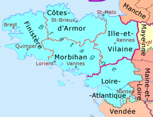
Deutsch: Die heutige Region Bretagne mit ihren Départements, vor dem Hintergrund der Provinzen am Ende des Ancien Régime. English: Map of the current region of Bretagne with its departments in 2022, on top of former provinces (distinguished by their background color) at end of the Old Regime. Français : Carte de l’actuelle région de Bretagne avec ses départements in 2022, au dessus des anciennes provinces (distinguées par leur couleur d'arrière-plan) à la fin de l'Ancien régime. |
| Date | |
| Source |
This image includes elements that have been taken or adapted from this file: This image includes elements that have been taken or adapted from this file: |
| Author | Ulamm (talk) |
Licensing[edit]
I, the copyright holder of this work, hereby publish it under the following licenses:

|
Permission is granted to copy, distribute and/or modify this document under the terms of the GNU Free Documentation License, Version 1.2 or any later version published by the Free Software Foundation; with no Invariant Sections, no Front-Cover Texts, and no Back-Cover Texts. A copy of the license is included in the section entitled GNU Free Documentation License. |
This file is licensed under the Creative Commons Attribution-Share Alike 4.0 International, 3.0 Unported, 2.5 Generic, 2.0 Generic and 1.0 Generic license.
- You are free:
- to share – to copy, distribute and transmit the work
- to remix – to adapt the work
- Under the following conditions:
- attribution – You must give appropriate credit, provide a link to the license, and indicate if changes were made. You may do so in any reasonable manner, but not in any way that suggests the licensor endorses you or your use.
- share alike – If you remix, transform, or build upon the material, you must distribute your contributions under the same or compatible license as the original.
You may select the license of your choice.
File history
Click on a date/time to view the file as it appeared at that time.
| Date/Time | Thumbnail | Dimensions | User | Comment | |
|---|---|---|---|---|---|
| current | 14:07, 29 November 2022 | | 1,135 × 873 (101 KB) | Ulamm (talk | contribs) | bay of Quimper |
| 18:21, 26 November 2022 |  | 1,135 × 873 (101 KB) | Ulamm (talk | contribs) | old names turquoise | |
| 19:27, 25 November 2022 |  | 1,135 × 873 (101 KB) | Ulamm (talk | contribs) | extern borders recoloured | |
| 19:18, 25 November 2022 |  | 1,135 × 873 (102 KB) | Ulamm (talk | contribs) | {{Information |Description={{de|Die heutige Region Normandie mit ihren Départements vor dem Hintergrund der Provinzen am Ende des Ancien Régime.}} {{en|Map of the actual region of Normandie with its departments on the background of the former provinces]].}} |Source=File:France location map-Provinces 1789.svg and {{AttribSVG|France location map-Regions and departements.svg|Sting}} |Date=2022-11-25 |Author=Ulamm ([[User talk:Ulamm|<span class="signature-talk">{{int:Talkpage... |
You cannot overwrite this file.
File usage on Commons
There are no pages that use this file.
File usage on other wikis
The following other wikis use this file:
- Usage on de.wikipedia.org