File:1790 Hoeck Karte Oberisenburg.png
Jump to navigation
Jump to search

Size of this preview: 800 × 577 pixels. Other resolutions: 320 × 231 pixels | 640 × 462 pixels | 1,024 × 739 pixels | 1,092 × 788 pixels.
Original file (1,092 × 788 pixels, file size: 1.18 MB, MIME type: image/png)
Captions
Captions
Add a one-line explanation of what this file represents
| Description |
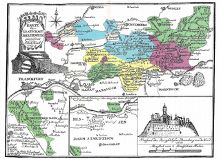
Deutsch: Karte der Grafschaft Oberisenburg (Isenburg-Birstein, Ysenburg-Büdingen-Büdingen, Ysenburg-Büdingen-Meerholz, Ysenburg-Büdingen-Wächtersbach) |
||||
| Date | |||||
| Source | Historisch-statistische Topographie der Grafschaft Oberisenburg, Jäger, Frankfurt am Main: 1790 | ||||
| Author | J. D. A. Hoeck (1763–1839), alternative Schreibweise: Johann D. Hoeck, Johann Daniel Albrecht Höck, Johann D. Höck, D. J. D. A. Höck, J. D. A. Höck, Johann D. Hök | ||||
| Permission (Reusing this file) |
|
||||
File history
Click on a date/time to view the file as it appeared at that time.
| Date/Time | Thumbnail | Dimensions | User | Comment | |
|---|---|---|---|---|---|
| current | 16:28, 24 May 2014 | | 1,092 × 788 (1.18 MB) | Waldnobbi (talk | contribs) | {{Information |Description ={{de|1=Karte der Grafschaft Oberisenburg (Isenburg-Birstein, Ysenburg-Büdingen-Büdingen, Ysenburg-Büdingen-Meerholz, Ysenburg-Büdingen-Wächtersbach) }} |Source =Historisch-statistische Topographie der Grafsch... |
You cannot overwrite this file.
File usage on Commons
There are no pages that use this file.
File usage on other wikis
The following other wikis use this file:
- Usage on de.wikipedia.org
- Usage on en.wikipedia.org
- Usage on es.wikipedia.org