File:1941年到1942年二戰歐洲戰場局勢.png
Jump to navigation
Jump to search
Size of this preview: 654 × 600 pixels. Other resolutions: 262 × 240 pixels | 523 × 480 pixels | 837 × 768 pixels | 1,090 × 1,000 pixels.
Original file (1,090 × 1,000 pixels, file size: 293 KB, MIME type: image/png)
Captions
Captions
Add a one-line explanation of what this file represents
| Annotations | This image is annotated: View the annotations at Commons |
Summary[edit]
| Description |
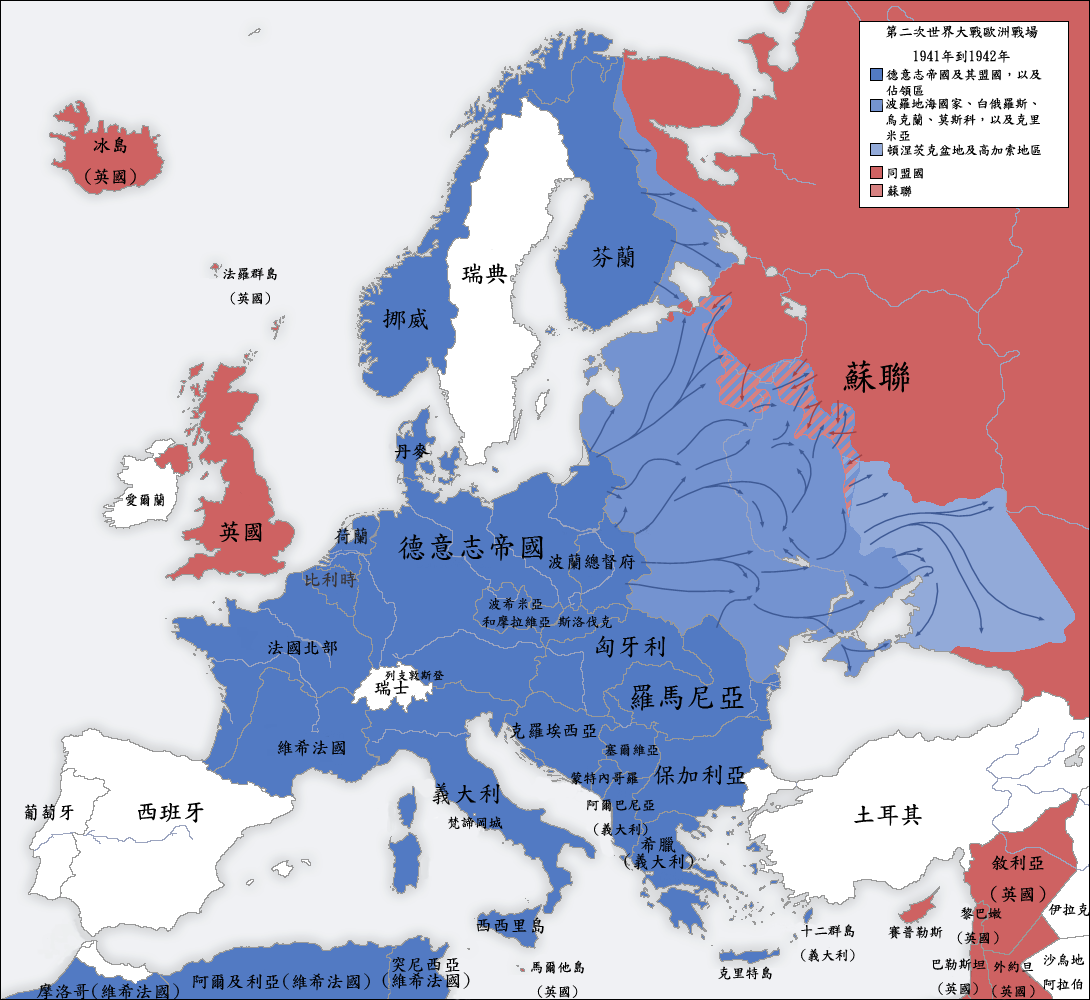
Deutsch: Karte der vom Deutschen Reich besetzten Gebiete und der Kriegsfronten im Zweiten Weltkrieg, 1941/42.
English: A map of German front of the Second World War circa 1941-1942.
Ελληνικά: Εδαφικές κατακτήσεις του Ράιχ
Español: Conquistas territoriales del Reich
中文(臺灣):1941年到1942年間,二戰歐洲戰場的局勢圖。 |
| Date | |
| Source | |
| Author | San Jose, Yenhochia |
| Other versions |
[]
|


Licensing[edit]
I, the copyright holder of this work, hereby publish it under the following license:
This file is licensed under the Creative Commons Attribution-Share Alike 4.0 International license.
- You are free:
- to share – to copy, distribute and transmit the work
- to remix – to adapt the work
- Under the following conditions:
- attribution – You must give appropriate credit, provide a link to the license, and indicate if changes were made. You may do so in any reasonable manner, but not in any way that suggests the licensor endorses you or your use.
- share alike – If you remix, transform, or build upon the material, you must distribute your contributions under the same or compatible license as the original.
File history
Click on a date/time to view the file as it appeared at that time.
| Date/Time | Thumbnail | Dimensions | User | Comment | |
|---|---|---|---|---|---|
| current | 17:39, 5 October 2019 | | 1,090 × 1,000 (293 KB) | Yenhochia (talk | contribs) | User created page with UploadWizard |
You cannot overwrite this file.
File usage on Commons
The following 9 pages use this file:
- File:1941年到1942年二戰歐洲戰場局勢.png
- File:2svitovavijnamapa.jpg
- File:Second world war europe 1941-1942 map de.png
- File:Second world war europe 1941-1942 map en.png
- File:Second world war europe 1941-1942 map hy.png
- File:Second world war europe 1941-1942 map pl.png
- File:WWII Europe 1941-1942 Map EN.png
- File:欧洲局势 1941-1942.png
- Template:Other versions/World War II in Europe, 1941-1942
File usage on other wikis
The following other wikis use this file:
- Usage on zh.wikipedia.org