File:2010 Atlantic hurricane rainfall.jpg
From Wikimedia Commons, the free media repository
Jump to navigation
Jump to search

Size of this preview: 800 × 380 pixels. Other resolutions: 320 × 152 pixels | 640 × 304 pixels | 1,024 × 487 pixels | 2,048 × 974 pixels.
Original file (2,048 × 974 pixels, file size: 444 KB, MIME type: image/jpeg)
File information
Structured data
Captions
Captions
Add a one-line explanation of what this file represents
Summary[edit]
| Description2010 Atlantic hurricane rainfall.jpg |
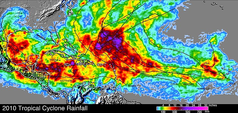
English: The 2010 Atlantic hurricane season was accurately predicted by the National Oceanic and Atmospheric Administration (NOAA) to be an active one with 14-23 storms and 8-14 hurricanes predicted. The National Hurricane Center (NHC) subsequently named 19 storms with 12 reaching hurricane strength.
The 2010 Atlantic hurricane season was the most active since the record breaking season of 2005. The images on the right show a comparison between the tropical cyclone rainfall occurring in these years. The tracks of tropical cyclones are shown with black lines. These tropical cyclone rainfall analyses were both made at NASA Goddard Space Flight Center using TRMM-based, near-real time Multi-satellite Precipitation data (TMPA). It is immediately obvious from this comparison that the major difference is the locations of tropical cyclones. During the 2010 hurricane season more hurricanes formed in the eastern Atlantic near the Cape Verde islands. These storms were steered around the southern and western edge of the Atlantic subtropical high and recurved into the north Atlantic without touching the United States mainland. For this reason the highest tropical cyclone rainfall totals were located over the open waters of the Atlantic north of Puerto Rico. Hurricane Earl did come close enough to cause strong winds and heavy rainfall along the coast of the northeastern United States. Southern Texas was also one of the few locations in the United States where 2010 tropical cyclone rainfall was greater than in 2005 |
| Date | |
| Source | http://trmm.gsfc.nasa.gov/publications_dir/2010_tc_rain.html |
| Author | NASA |
| Permission (Reusing this file) |
Public Domain |
Licensing[edit]
| Public domainPublic domainfalsefalse |
| This file is in the public domain in the United States because it was solely created by NASA. NASA copyright policy states that "NASA material is not protected by copyright unless noted". (See Template:PD-USGov, NASA copyright policy page or JPL Image Use Policy.) |  | |
 |
Warnings:
|
File history
Click on a date/time to view the file as it appeared at that time.
| Date/Time | Thumbnail | Dimensions | User | Comment | |
|---|---|---|---|---|---|
| current | 16:47, 9 December 2010 |  | 2,048 × 974 (444 KB) | Cyclonebiskit (talk | contribs) | {{Information |Description={{en|1=The 2010 Atlantic hurricane season was accurately predicted by the National Oceanic and Atmospheric Administration (NOAA) to be an active one with 14-23 storms and 8-14 hurricanes predicted. The National Hurricane Center |
You cannot overwrite this file.
File usage on Commons
There are no pages that use this file.
File usage on other wikis
The following other wikis use this file:
- Usage on pt.wikipedia.org