File:2014 09 23 Wegekreuz an der L516.jpg
Original file (1,130 × 2,160 pixels, file size: 2.57 MB, MIME type: image/jpeg)
Captions
Contents
Summary
[edit]Description2014 09 23 Wegekreuz an der L516.jpg |
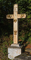
Deutsch: Wegekreuz, Arma Christi
Lage: L516 an der Deutschen Weinstraße südlich der Ortslage von Deidesheim bei der Abfahrt auf die K 10, Ruppertsberg, Landkreis Bad Dürkheim, Rheinland-Pfalz English: way cross |
Date | Taken on 25 September 2014, 11:33:22 |
Source | Self-photographed |
Author | Friedrich Haag |
Camera location | 49° 23′ 54.56″ N, 8° 11′ 08.73″ E | View this and other nearby images on: OpenStreetMap | 49.398490; 8.185757 |
---|
Licensing
[edit]- You are free:
- to share – to copy, distribute and transmit the work
- to remix – to adapt the work
- Under the following conditions:
- attribution – You must give appropriate credit, provide a link to the license, and indicate if changes were made. You may do so in any reasonable manner, but not in any way that suggests the licensor endorses you or your use.
- share alike – If you remix, transform, or build upon the material, you must distribute your contributions under the same or compatible license as the original.
Other
[edit]This image was uploaded as part of Wiki Loves Monuments 2014.
Afrikaans ∙ Alemannisch ∙ العربية ∙ جازايرية ∙ azərbaycanca ∙ Bikol Central ∙ беларуская ∙ беларуская (тарашкевіца) ∙ български ∙ বাংলা ∙ brezhoneg ∙ bosanski ∙ català ∙ čeština ∙ Cymraeg ∙ dansk ∙ Deutsch ∙ Zazaki ∙ Ελληνικά ∙ English ∙ Esperanto ∙ español ∙ eesti ∙ euskara ∙ فارسی ∙ suomi ∙ français ∙ Frysk ∙ Gaeilge ∙ galego ∙ עברית ∙ हिन्दी ∙ hrvatski ∙ magyar ∙ հայերեն ∙ Bahasa Indonesia ∙ Ido ∙ italiano ∙ 日本語 ∙ ქართული ∙ 한국어 ∙ кыргызча ∙ Lëtzebuergesch ∙ latviešu ∙ Malagasy ∙ македонски ∙ മലയാളം ∙ Bahasa Melayu ∙ Malti ∙ norsk bokmål ∙ नेपाली ∙ Nederlands ∙ norsk nynorsk ∙ norsk ∙ polski ∙ português ∙ português do Brasil ∙ română ∙ русский ∙ sicilianu ∙ davvisámegiella ∙ slovenčina ∙ slovenščina ∙ shqip ∙ српски / srpski ∙ svenska ∙ ไทย ∙ Tagalog ∙ Türkçe ∙ українська ∙ اردو ∙ oʻzbekcha / ўзбекча ∙ Yorùbá ∙ 中文 ∙ 中文(中国大陆) ∙ 中文(简体) ∙ 中文(繁體) ∙ 中文(香港) ∙ 中文(臺灣) ∙ +/− |
Assessment
[edit]
This image has been assessed using the Quality image guidelines and is considered a Quality image.
العربية ∙ جازايرية ∙ беларуская ∙ беларуская (тарашкевіца) ∙ български ∙ বাংলা ∙ català ∙ čeština ∙ Cymraeg ∙ Deutsch ∙ Schweizer Hochdeutsch ∙ Zazaki ∙ Ελληνικά ∙ English ∙ Esperanto ∙ español ∙ eesti ∙ euskara ∙ فارسی ∙ suomi ∙ français ∙ galego ∙ עברית ∙ हिन्दी ∙ hrvatski ∙ magyar ∙ հայերեն ∙ Bahasa Indonesia ∙ italiano ∙ 日本語 ∙ Jawa ∙ ქართული ∙ 한국어 ∙ kurdî ∙ Lëtzebuergesch ∙ lietuvių ∙ македонски ∙ മലയാളം ∙ मराठी ∙ Bahasa Melayu ∙ Nederlands ∙ Norfuk / Pitkern ∙ polski ∙ português ∙ português do Brasil ∙ rumantsch ∙ română ∙ русский ∙ sicilianu ∙ slovenčina ∙ slovenščina ∙ shqip ∙ српски / srpski ∙ svenska ∙ தமிழ் ∙ తెలుగు ∙ ไทย ∙ Tagalog ∙ toki pona ∙ Türkçe ∙ українська ∙ vèneto ∙ Tiếng Việt ∙ 中文 ∙ 中文(简体) ∙ 中文(繁體) ∙ +/− |
File history
Click on a date/time to view the file as it appeared at that time.
Date/Time | Thumbnail | Dimensions | User | Comment | |
---|---|---|---|---|---|
current | 11:18, 27 November 2014 | 1,130 × 2,160 (2.57 MB) | F. Riedelio (talk | contribs) | Ausrichtung und Entwicklung verbessert | |
12:14, 30 September 2014 | 1,130 × 2,160 (2.02 MB) | F. Riedelio (talk | contribs) | Bei anderer Tageszeit neu aufgenommen | ||
17:37, 27 September 2014 | 1,178 × 2,160 (1.68 MB) | F. Riedelio (talk | contribs) | Neu aufgenommen und Auflösung erhöht | ||
13:34, 25 September 2014 | 603 × 1,200 (711 KB) | F. Riedelio (talk | contribs) | User created page with UploadWizard |
You cannot overwrite this file.
File usage on Commons
The following 6 pages use this file:
- User:F. Riedelio/Kulturdenkmäler/Kulturdenkmäler in Ruppertsberg
- User:F. Riedelio/Kulturdenkmäler Chronologisch/2014
- User:F. Riedelio/Quality Image Promotion/2014
- Commons:Forum/Archiv/2015/August
- Commons:Quality images/Subject/Objects/Statues, Monuments and Plaques/archive 2014
- Commons:Quality images candidates/Archives November 30 2014
File usage on other wikis
The following other wikis use this file:
- Usage on de.wikipedia.org
Metadata
This file contains additional information such as Exif metadata which may have been added by the digital camera, scanner, or software program used to create or digitize it. If the file has been modified from its original state, some details such as the timestamp may not fully reflect those of the original file. The timestamp is only as accurate as the clock in the camera, and it may be completely wrong.
Camera manufacturer | ma Chr |
---|---|
Camera model | isti |
Author | 30 11:31:51 |
Copyright holder |
|
Exposure time | 1/350 sec (0.0028571428571429) |
F-number | f/8 |
ISO speed rating | 100 |
Date and time of data generation | 09:15, 28 September 2014 |
Lens focal length | 24 mm |
Latitude | 49° 23′ 54.42″ N |
Longitude | 8° 11′ 7.93″ E |
Altitude | 135 meters above sea level |
Label | Wegekreuz an der Deutschen Weinstraße südlich der Ortslage von Deidesheim bei der Abfahrt auf die K 10 |
Headline | Kulturdenkmaeler_Ruppertsberg |
Online copyright statement | http://creativecommons.org/licenses/by-sa/3.0/de/legalcode |
Short title |
|
Image title |
|
Usage terms | |
City shown | Ruppertsberg |
Orientation | Normal |
Horizontal resolution | 1.0032778985644 dpi |
Vertical resolution | 181.90625 dpi |
File change date and time | 6 (Windows) |
Exposure Program | Manual |
Exif version | 2.3 |
Date and time of digitizing | 09:15, 28 September 2014 |
APEX shutter speed | 8.451211 |
APEX aperture | 6 |
APEX exposure bias | 0 |
Maximum land aperture | 3 APEX (f/2.83) |
Metering mode | Pattern |
Flash | Flash did not fire, compulsory flash suppression |
Color space | sRGB |
Focal plane X resolution | 5,715.545755237 |
Focal plane Y resolution | 5,808.4033613445 |
Focal plane resolution unit | inches |
Custom image processing | Normal process |
Exposure mode | Manual exposure |
White balance | Auto white balance |
Scene capture type | Standard |
GPS tag version | 0.0.2.2 |
Serial number of camera | 0580515884 |
Lens used | 24-70mm |
Software used | Adobe Photoshop Lightroom 5.6 (Windows) |
Date metadata was last modified | 13:12, 27 November 2014 |
Unique ID of original document | FD44BC3E022AF4798392F9D77FE10B57 |
Copyright status | Copyright status not set |
Keywords |
|
Province or state shown | Rheinland-Pfalz |
Country shown | Deutschland |
Code for country shown | DEU |
Sublocation of city shown | L516 |
IIM version | 4 |
Structured data
Items portrayed in this file
depicts
25 September 2014
49°23'54.56400"N, 8°11'8.72401"E
0.00285714285714285714 second
24 millimetre
100
image/jpeg
e408d70676342bbff17282580028717aa1b659b1
2,690,122 byte
2,160 pixel
1,130 pixel
- Rhineland-Palatinate photographs taken on 2014-09-25
- CC-BY-SA-3.0-DE
- Self-published work
- Images from Wiki Loves Monuments 2014
- Images from Wiki Loves Monuments 2014 in Germany
- Quality images
- Images from Wiki Loves Monuments 2014, DE-RP
- Uploaded via Campaign:wlm-de-rp
- Images by F. Riedelio
- Quality images by F. Riedelio
- Quality images of Germany by F. Riedelio
- Taken with Canon EOS 7D
- Quality images from Wiki Loves Monuments 2014 in Germany
- Quality images of cultural heritage monuments in Rhineland-Palatinate
- Quality images of wayside crosses in Germany