File:20150629 At the Top of Misiryeong Ridge.jpg
Jump to navigation
Jump to search

Size of this preview: 800 × 600 pixels. Other resolutions: 320 × 240 pixels | 640 × 480 pixels | 1,024 × 768 pixels | 1,280 × 960 pixels | 2,560 × 1,920 pixels | 3,264 × 2,448 pixels.
Original file (3,264 × 2,448 pixels, file size: 2.07 MB, MIME type: image/jpeg)
Captions
Captions
Add a one-line explanation of what this file represents
Summary[edit]
| Description |
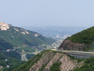
English: At the Top of Misiryeong Ridge, Taebaek Mountains, Gangwon Province, Korea - There are two ways to get from Inje to Sokcho: one is through the 'Misiryeong Tunnel' and the other is to go over 'Misiryeong Yetgil'. If you have more time to appreciate nature, you should take the mountain route because magnificent scenery awaits visitors at the top. 한국어: 미시령옛길 정상에서 바라 본 속초시와 동쪽 바다 |
| Date | |
| Source | Own work |
| Author | Misiryeong |
Licensing[edit]
I, the copyright holder of this work, hereby publish it under the following license:
This file is licensed under the Creative Commons Attribution-Share Alike 4.0 International license.
- You are free:
- to share – to copy, distribute and transmit the work
- to remix – to adapt the work
- Under the following conditions:
- attribution – You must give appropriate credit, provide a link to the license, and indicate if changes were made. You may do so in any reasonable manner, but not in any way that suggests the licensor endorses you or your use.
- share alike – If you remix, transform, or build upon the material, you must distribute your contributions under the same or compatible license as the original.
File history
Click on a date/time to view the file as it appeared at that time.
| Date/Time | Thumbnail | Dimensions | User | Comment | |
|---|---|---|---|---|---|
| current | 15:37, 11 July 2015 | | 3,264 × 2,448 (2.07 MB) | Misiryeong (talk | contribs) | User created page with UploadWizard |
You cannot overwrite this file.
File usage on Commons
There are no pages that use this file.
File usage on other wikis
The following other wikis use this file:
- Usage on de.wikipedia.org
- Usage on ko.wikipedia.org
- Usage on pl.wikipedia.org