File:2016 Berlin attack route map.svg
Jump to navigation
Jump to search

Size of this PNG preview of this SVG file: 780 × 580 pixels. Other resolutions: 320 × 238 pixels | 640 × 476 pixels | 1,024 × 761 pixels | 1,280 × 952 pixels | 2,560 × 1,904 pixels.
Original file (SVG file, nominally 780 × 580 pixels, file size: 2.99 MB)
Captions
Captions
Add a one-line explanation of what this file represents
Summary[edit]
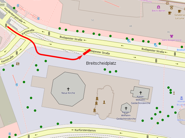
| Description | and Der ISIS-Anschlag von Berlin (in German). BILD (December 22, 2016). |
| Date | |
| Source | Own work |
| Author | Phoenix7777 |
Licensing[edit]
I, the copyright holder of this work, hereby publish it under the following license:
This file is licensed under the Creative Commons Attribution-Share Alike 4.0 International license.
- You are free:
- to share – to copy, distribute and transmit the work
- to remix – to adapt the work
- Under the following conditions:
- attribution – You must give appropriate credit, provide a link to the license, and indicate if changes were made. You may do so in any reasonable manner, but not in any way that suggests the licensor endorses you or your use.
- share alike – If you remix, transform, or build upon the material, you must distribute your contributions under the same or compatible license as the original.
| Description |
English: Map of earthquakes in 2016 as of Sep 24, 2016 |
|||
| Date | ||||
| Source | openstreetmap.org | |||
| Creator |
Own work OpenStreetMap contributors |
|||
| Permission (Reusing this file) |
OpenStreetMap data is available under the Open Database License (details). Map tiles are licensed under the Creative Commons Attribution-ShareAlike 2.0 license (CC-BY-SA 2.0).
This file is licensed under the Creative Commons Attribution-Share Alike 2.0 Generic license.
|
|||
| Georeferencing | If inappropriate please set warp_status = skip to hide. |
File history
Click on a date/time to view the file as it appeared at that time.
| Date/Time | Thumbnail | Dimensions | User | Comment | |
|---|---|---|---|---|---|
| current | 11:48, 26 December 2016 | | 780 × 580 (2.99 MB) | Phoenix7777 (talk | contribs) | Extended the route a bit |
| 09:35, 23 December 2016 |  | 780 × 580 (2.99 MB) | Phoenix7777 (talk | contribs) | Cropped Hardenbergstraße version | |
| 23:06, 22 December 2016 |  | 984 × 721 (2.99 MB) | Phoenix7777 (talk | contribs) | Cropped | |
| 11:37, 22 December 2016 |  | 1,484 × 1,096 (2.99 MB) | Phoenix7777 (talk | contribs) | Neutral version. Neither Hardenbergstraße nor Kantstraße | |
| 11:36, 22 December 2016 |  | 1,484 × 1,096 (2.99 MB) | Phoenix7777 (talk | contribs) | Kantstraße version | |
| 02:50, 22 December 2016 |  | 1,484 × 1,096 (2.99 MB) | Phoenix7777 (talk | contribs) | Shorten the route | |
| 23:15, 21 December 2016 |  | 1,484 × 1,096 (2.99 MB) | Phoenix7777 (talk | contribs) | Updated the route of the truck | |
| 15:59, 21 December 2016 |  | 1,484 × 1,096 (2.9 MB) | Furfur (talk | contribs) | bessere Auflösung / higher resolution | |
| 06:49, 21 December 2016 |  | 653 × 493 (565 KB) | Phoenix7777 (talk | contribs) | User created page with UploadWizard |
You cannot overwrite this file.
File usage on Commons
The following 4 pages use this file:
File usage on other wikis
The following other wikis use this file:
- Usage on ar.wikipedia.org
- Usage on azb.wikipedia.org
- Usage on ca.wikipedia.org
- Usage on da.wikipedia.org
- Usage on de.wikipedia.org
- Usage on el.wikipedia.org
- Usage on en.wikipedia.org
- Usage on es.wikipedia.org
- Usage on eu.wikipedia.org
- Usage on ga.wikipedia.org
- Usage on he.wikipedia.org
- Usage on hu.wikipedia.org
- Usage on it.wikipedia.org
- Usage on la.wikipedia.org
- Usage on ms.wikipedia.org
- Usage on no.wikipedia.org
- Usage on pl.wikipedia.org
- Usage on pt.wikipedia.org
- Usage on ro.wikipedia.org
- Usage on ru.wikipedia.org
- Usage on sv.wikipedia.org
- Usage on www.wikidata.org
- Usage on zh.wikipedia.org