File:2016 Central Italy earthquake aftershock distribution.png
Jump to navigation
Jump to search
Size of this preview: 800 × 588 pixels. Other resolutions: 320 × 235 pixels | 640 × 470 pixels | 845 × 621 pixels.
Original file (845 × 621 pixels, file size: 693 KB, MIME type: image/png)
Captions
Captions
Add a one-line explanation of what this file represents
Summary[edit]
| Description |
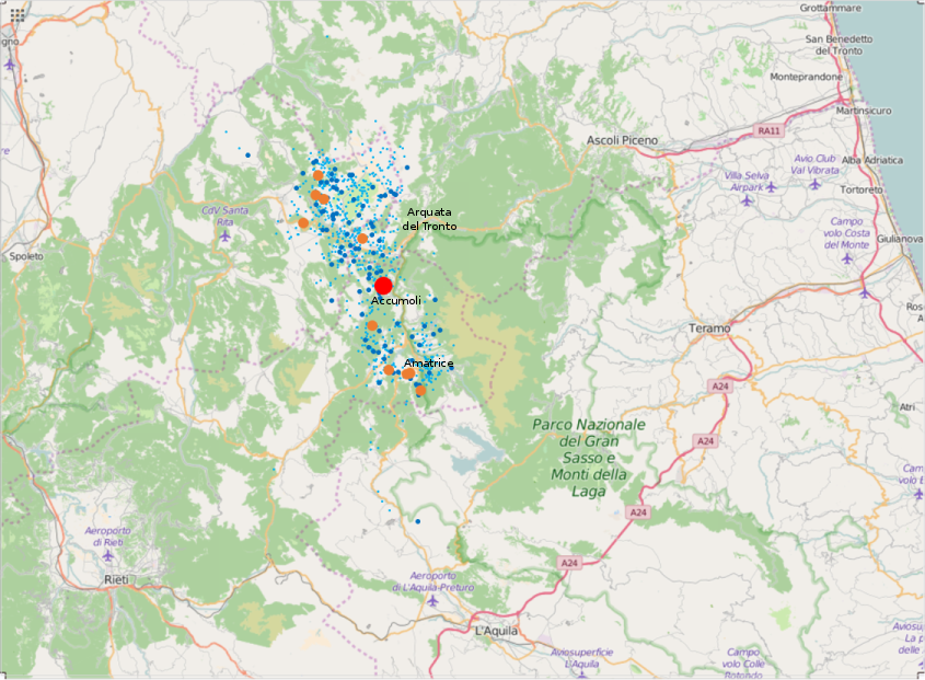
English: 2016 Central Italy earthquake aftershock distribution, August 24-25. Red: Main shock, Orange: 6 > M ≧ 4. Blue: 4 > M ≧ 3, Light blue: 3 > M. In the middle: Accumoli and Amatrice. |
| Date | |
| Source |
Own work Data source: Data fromEarthquake list. Istituto Nazionale di Geofisica e Vulcanologia (National Institute of Geophysics and Volcanology). (Search conditions: start time=2016-08-24 00:00:00, end time=2016-08-25 23:59:59, min magnitude=0, max magnitude=10, min depth=0km, max depth=1000km, latitude=42.71, longitude=13.24, max radius=30km) |
| Author | Phoenix7777 |
| Other versions |
|

.svg)
Licensing[edit]
I, the copyright holder of this work, hereby publish it under the following license:
This file is licensed under the Creative Commons Attribution-Share Alike 4.0 International license.
- You are free:
- to share – to copy, distribute and transmit the work
- to remix – to adapt the work
- Under the following conditions:
- attribution – You must give appropriate credit, provide a link to the license, and indicate if changes were made. You may do so in any reasonable manner, but not in any way that suggests the licensor endorses you or your use.
- share alike – If you remix, transform, or build upon the material, you must distribute your contributions under the same or compatible license as the original.
| Description |
English: 2016 Central Italy earthquake aftershock distribution, August 24-25. |
|||
| Date | ||||
| Source | openstreetmap.org | |||
| Creator |
Own work OpenStreetMap contributors |
|||
| Permission (Reusing this file) |
OpenStreetMap data is available under the Open Database License (details). Map tiles are licensed under the Creative Commons Attribution-ShareAlike 2.0 license (CC-BY-SA 2.0).
This file is licensed under the Creative Commons Attribution-Share Alike 2.0 Generic license.
|
|||
| Georeferencing | If inappropriate please set warp_status = skip to hide. |
File history
Click on a date/time to view the file as it appeared at that time.
| Date/Time | Thumbnail | Dimensions | User | Comment | |
|---|---|---|---|---|---|
| current | 09:11, 29 August 2016 | | 845 × 621 (693 KB) | Phoenix7777 (talk | contribs) | added locations |
| 13:38, 27 August 2016 |  | 1,126 × 827 (1.17 MB) | Phoenix7777 (talk | contribs) | longitude 12.7-14.0 latitude 42.3-43.0 | |
| 04:38, 27 August 2016 |  | 914 × 623 (631 KB) | Phoenix7777 (talk | contribs) | User created page with UploadWizard |
You cannot overwrite this file.
File usage on Commons
The following 2 pages use this file: