File:20190223125DR Braunsdorf (Wilsdruff) Gasthof zur Sonne.jpg
Jump to navigation
Jump to search

Size of this preview: 800 × 599 pixels. Other resolutions: 320 × 239 pixels | 640 × 479 pixels | 1,024 × 766 pixels | 1,280 × 958 pixels | 2,560 × 1,916 pixels | 3,563 × 2,666 pixels.
Original file (3,563 × 2,666 pixels, file size: 6.77 MB, MIME type: image/jpeg)
Captions
Captions
Add a one-line explanation of what this file represents
Summary[edit]
| Description |
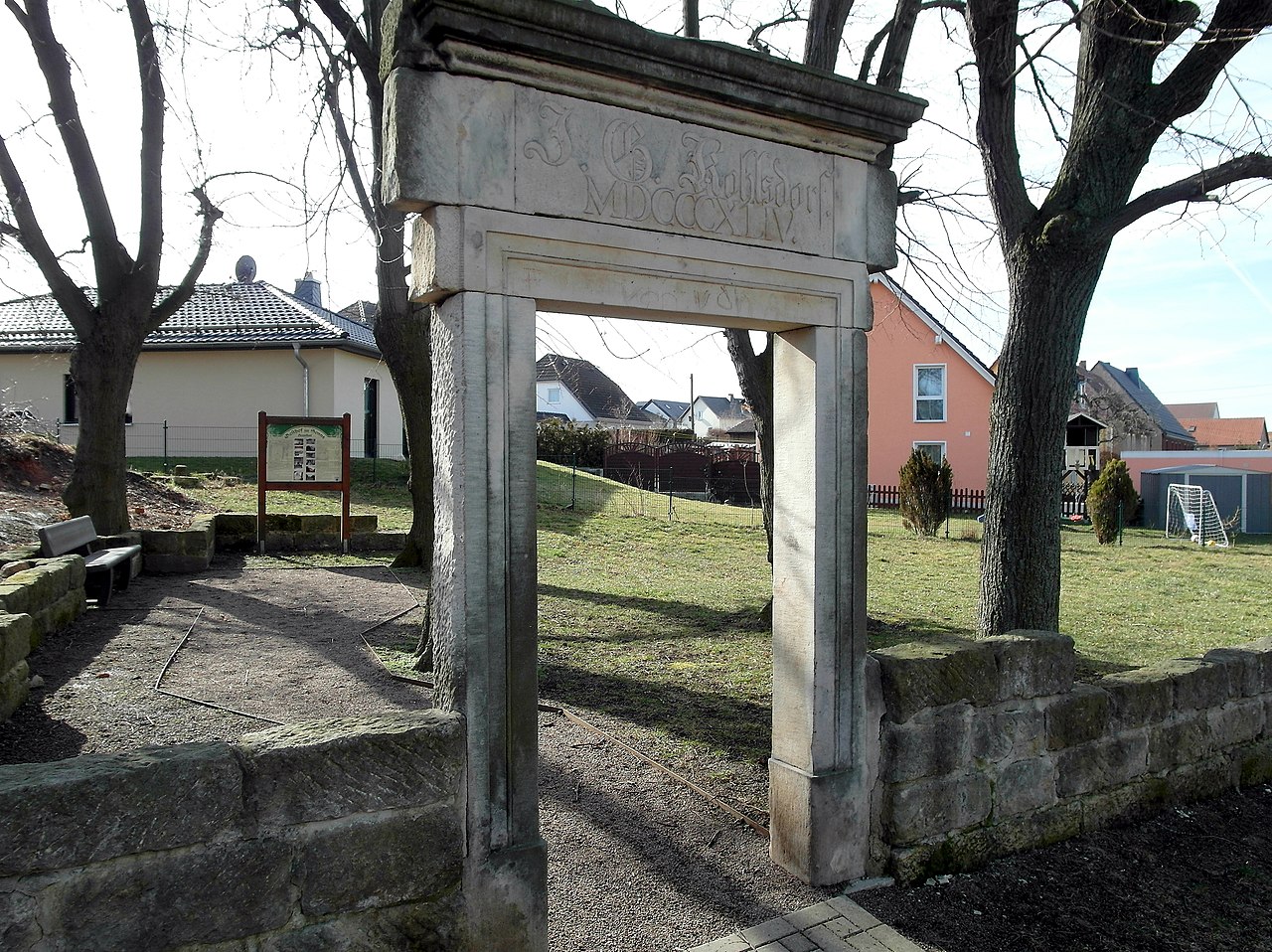
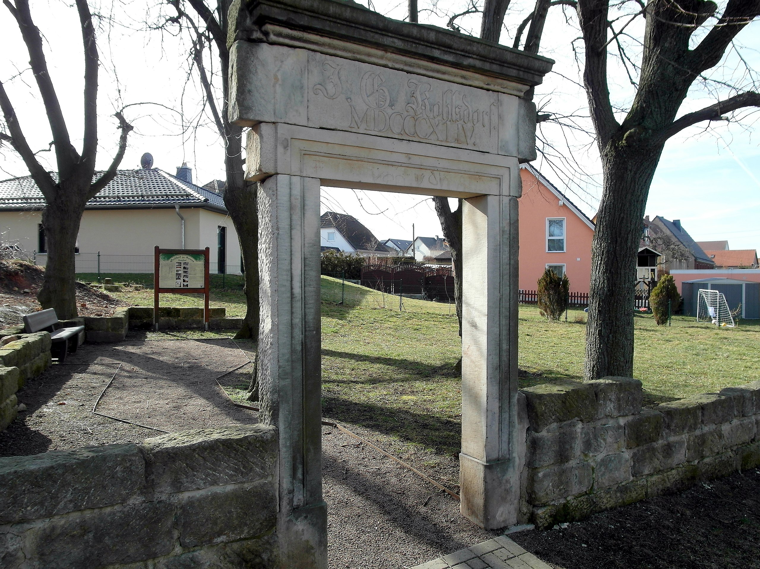
Deutsch: 23.02.2019 01737 Braunsdorf (Wilsdruff), Platz der Jugend (GMP: 51.016458,13.573637): Hier stand bis zu seiner Verwüstung durch Vandalismus nach der Wende und seinem Abriß im August 2006 der "Gasthof zur Sonne". Der Gasthof wurde 1844 von Johann Gottlieb Kohlsdorf erbaut und 1867/68 zum Teil vom Rittergut aufgekauft. In der Folgezeit wechseln die Eigentümer und Pächter oft, aber die "Sonne" blieb ein beliebter kultureller Mittelpunkt der Dorfgemeinschaft, vor allem auch in der DDR-Zeit. 1974 wurde durch den Dorfclub Saal und Gaststätte mit in vielen freiwilligen Arbeitsstunden gründlich überholt und teils erneuert. In den Folgejahren gab es viele Veranstaltungen, deren Träger der Dorfclub war. Mit Auflösung der Konsumgenossenschaft Freital 1992 wurde der Gaststättenbetrieb eingestellt. Der damalige Jugendclub Braunsdorf führte weiterhin Veranstaltungen in eigener Regie durch. Das alles endete 1995 mit der Rückübertragung an Gerhard Mann. Es beginnt eine bewußte, von Vandalismus geprägte Zerstörung und ein allmählicher Zerfall. Im Herbst 2006 erfolgte der Abriß. Heimatfreunde habe 2009 das alte Hausportal mit der Inschrift "J. G. Kohlsdorf MDCCCXLIV", das sich ursprünlich flächenbündig in der Hauswand befand, als Erinnerungsmal hier am ehemaligen Biergarten (in Bild) aufgestellt. (Quelle: Infotafel des Orts-Chronisten Erhart Heinze - 2011) [SAM9619.JPG]20190223125DR.JPG(c)Blobelt |
||||||||||||||
| Date | |||||||||||||||
| Source | Own work | ||||||||||||||
| Author |
|
||||||||||||||

_Gasthof_zur_Sonne.jpg&action=edit§ion=1)
| Object location | | View this and other nearby images on: OpenStreetMap |
|---|
_Gasthof_zur_Sonne.jpg¶ms=051.016458_N_0013.573637_E_globe:Earth_class:object_type:object__&language=en)
Licensing[edit]
_Gasthof_zur_Sonne.jpg&action=edit§ion=2)
This file is licensed under the Creative Commons Attribution-Share Alike 4.0 International license.
- You are free:
- to share – to copy, distribute and transmit the work
- to remix – to adapt the work
- Under the following conditions:
- attribution – You must give appropriate credit, provide a link to the license, and indicate if changes were made. You may do so in any reasonable manner, but not in any way that suggests the licensor endorses you or your use.
- share alike – If you remix, transform, or build upon the material, you must distribute your contributions under the same or compatible license as the original.
File history
Click on a date/time to view the file as it appeared at that time.
| Date/Time | Thumbnail | Dimensions | User | Comment | |
|---|---|---|---|---|---|
| current | 20:25, 24 February 2019 | | 3,563 × 2,666 (6.77 MB) | Jörg Blobelt (talk | contribs) | User created page with UploadWizard |
You cannot overwrite this file.
File usage on Commons
There are no pages that use this file.
File usage on other wikis
The following other wikis use this file:
- Usage on de.wikipedia.org
_Gasthof_zur_Sonne.jpg&oldid=758156808)