File:State Highway 78 Bridge at the Red River.jpg
(Redirected from File:78redriver.jpg)
Size of this preview: 800 × 533 pixels. Other resolutions: 320 × 213 pixels | 640 × 427 pixels | 1,024 × 683 pixels | 1,280 × 853 pixels | 2,560 × 1,706 pixels | 3,947 × 2,631 pixels.
Original file (3,947 × 2,631 pixels, file size: 3.13 MB, MIME type: image/jpeg)
Captions
Captions
Add a one-line explanation of what this file represents
|
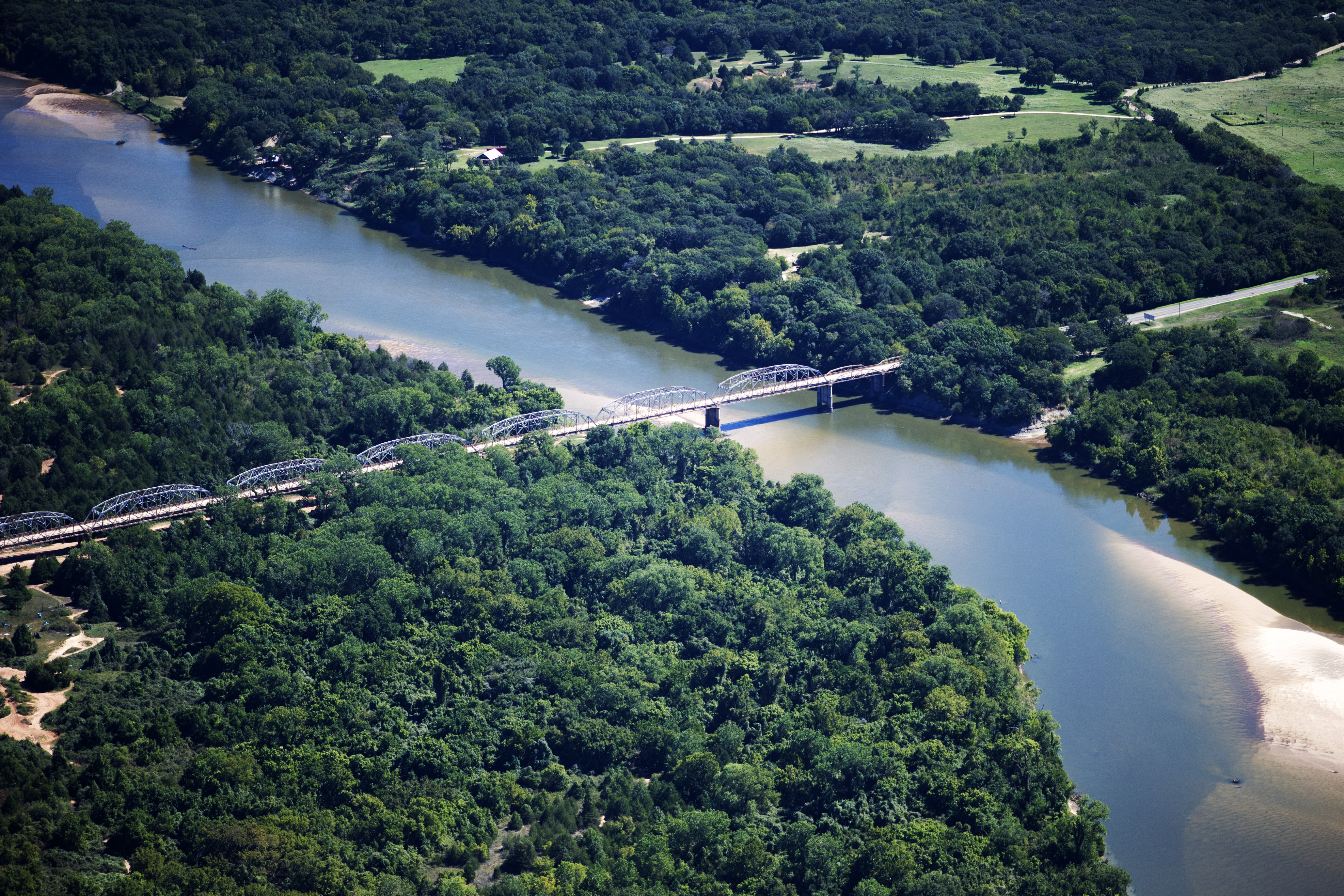
This is an image of a place or building that is listed on the National Register of Historic Places in the United States of America. Its reference number is 96001517. |
| Description |
English: Aerial view of the State Highway No. 78 Bridge — which carries Oklahoma State Highway 78 and Texas State Highway 78 over the Red River of the South.
|
||
| Date | |||
| Source | Own work | ||
| Author | Henley Quadling | ||
| Permission (Reusing this file) |
I, the copyright holder of this work, hereby publish it under the following licenses: This file is licensed under the Creative Commons Attribution-Share Alike 3.0 Unported license.
You may select the license of your choice. |

| Object location | | View this and other nearby images on: OpenStreetMap |
|---|
File history
Click on a date/time to view the file as it appeared at that time.
| Date/Time | Thumbnail | Dimensions | User | Comment | |
|---|---|---|---|---|---|
| current | 21:43, 30 September 2010 | | 3,947 × 2,631 (3.13 MB) | Unherdable (talk | contribs) | {{Information |Description=Aerial view of Highway 78 Bridge at the Red River |Source={{own}} |Date=2010-09-29 |Author= Henley Quadling |Permission= |other_versions= }} |
You cannot overwrite this file.
File usage on Commons
The following 2 pages use this file:
- Commons:Files used on the AARoads Wiki/60
- File:78redriver.jpg (file redirect)
File usage on other wikis
The following other wikis use this file:
- Usage on ar.wikipedia.org
- Usage on de.wikipedia.org
- Usage on en.wikipedia.org
- Bryan County, Oklahoma
- Red River of the South
- Oklahoma State Highway 78
- List of bridges on the National Register of Historic Places in Oklahoma
- List of bridges on the National Register of Historic Places in Texas
- State Highway 78 Bridge at the Red River
- National Register of Historic Places listings in Bryan County, Oklahoma
- National Register of Historic Places listings in Fannin County, Texas
- National Register of Historic Places listings in the Metroplex region of Texas: Other
- Usage on lt.wikipedia.org
- Usage on no.wikipedia.org
- Usage on sh.wikipedia.org
- Usage on www.wikidata.org
Metadata
Categories:
- Bridges over the Red River of the South in Oklahoma
- Bridges over the Red River of the South in Texas
- Through truss bridges in Oklahoma
- Through truss bridges in Texas
- Bridges completed in 1937
- Bridges on the National Register of Historic Places in Oklahoma
- Bridges on the National Register of Historic Places in Texas
- National Register of Historic Places in Bryan County, Oklahoma
- National Register of Historic Places in Fannin County, Texas
- Oklahoma State Highway 78
- State highways in Texas
- Built in Texas in 1937
- River bends in Oklahoma
- Bars (geology) in the United States