File:91L Jun 5 2013 1315Z.png
Jump to navigation
Jump to search

Size of this preview: 800 × 450 pixels. Other resolutions: 320 × 180 pixels | 640 × 360 pixels | 1,024 × 576 pixels | 1,280 × 720 pixels | 2,048 × 1,152 pixels.
Original file (2,048 × 1,152 pixels, file size: 3.31 MB, MIME type: image/png)
Captions
Captions
Add a one-line explanation of what this file represents
Summary[edit]
| Description |
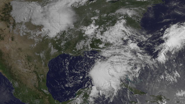
English: The broad area of low pressure over the Gulf of Mexico is producing disorganized thunderstorms and strong gusty winds, although the circulation remains poorly defined. Environmental conditions could become a little more conducive for development over the next day or so, and a tropical depression or storm could form before the system moves over mainland Florida. This image was taken by GOES East at 1315Z on June 5, 2013. |
| Date | |
| Source | http://www.nnvl.noaa.gov/MediaDetail2.php?MediaID=1364&MediaTypeID=1 |
| Author | The National Oceanic and Atmospheric Administration |
Licensing[edit]
This image is in the public domain because it contains materials that originally came from the U.S. National Oceanic and Atmospheric Administration, taken or made as part of an employee's official duties.
|
File history
Click on a date/time to view the file as it appeared at that time.
| Date/Time | Thumbnail | Dimensions | User | Comment | |
|---|---|---|---|---|---|
| current | 08:59, 8 April 2018 | | 2,048 × 1,152 (3.31 MB) | A1Cafel (talk | contribs) | original |
| 22:26, 5 June 2013 |  | 2,048 × 1,152 (3.73 MB) | Supportstorm (talk | contribs) | {{Information |Description ={{en|1=The broad area of low pressure over the Gulf of Mexico is producing disorganized thunderstorms and strong gusty winds, although the circulation remains poorly defined. Environmental conditions could become a little... |
You cannot overwrite this file.
File usage on Commons
The following page uses this file: