File:AMH-2550-NA Ground plan of the Fort of Good Hope with the start of a new pentagon.jpg
Jump to navigation
Jump to search

Size of this preview: 448 × 600 pixels. Other resolutions: 179 × 240 pixels | 358 × 480 pixels | 573 × 768 pixels | 764 × 1,024 pixels | 1,792 × 2,400 pixels.
Original file (1,792 × 2,400 pixels, file size: 598 KB, MIME type: image/jpeg)
Captions
Captions
Add a one-line explanation of what this file represents
Summary[edit]
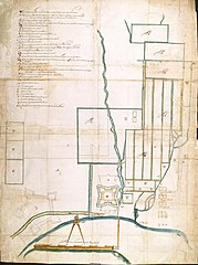
Nederlands: Plan van fort de Goede Hoop, met het begonnen nieuwe project voor een vijfhoek
English: Ground plan of the Fort of Good Hope with the start of a new pentagon( |
||||||||||||||||||||||||
|---|---|---|---|---|---|---|---|---|---|---|---|---|---|---|---|---|---|---|---|---|---|---|---|---|
| Author |
Nederlands: Anoniem / Anonymous (landmeter / kaartenmaker), Pieter Potter (gewerkt naar)
English: Anoniem / Anonymous (land surveyor / mapmaker), Pieter Potter (copied after) |
|||||||||||||||||||||||
| Title |
Nederlands: Plan van fort de Goede Hoop, met het begonnen nieuwe project voor een vijfhoek
English: Ground plan of the Fort of Good Hope with the start of a new pentagon |
|||||||||||||||||||||||
| Description |
Nederlands: Titel in catalogus Leupe (NA): Plan van fort de Goede Hoop, met het begonnen nieuwe project voor een Vyfhoek, aanleg van de Stad enz..
Legenda: A-Z, a-h De volgende straatnamen staan aangegeven op de kaart: Olifant-, Reijger en Heerestraat.English: The original title according to the catalogue Leupe (NA) reads: Plan van fort de Goede Hoop, met het begonnen nieuwe project voor een Vyfhoek, aanleg van de Stad enz..
Key: A-Z, a-h The following streets are noted: De Olifant-, Reijger en Heerestraat. |
|||||||||||||||||||||||
| Date | circa 1665 | |||||||||||||||||||||||
| Medium |
Nederlands: ingekleurde tekening op papier
English: coloured drawing on paper |
|||||||||||||||||||||||
| Dimensions | height: 767 mm (30.19 in); width: 1,023 mm (40.27 in) | |||||||||||||||||||||||
| Collection |
|
|||||||||||||||||||||||
| Accession number |
NL-HaNA_4.VEL_825 (old number: VEL0825) |
|||||||||||||||||||||||
| Inscriptions |
Compagnies Fort de goede Hoope ende Huijsingen daerbinnen
|
|||||||||||||||||||||||
| Notes |
English: Subjects: chart / map / plan, fortification, estate / plantation, hospital / lazaret, garden / ornamental garden, key
Nederlands: Onderwerpen: plattegrond / kaart, vesting, landerij / plantage, ziekenhuis / lazaret, tuin / siertuin, legenda
English: Fort: this image is related to a VOC fort called kasteel de Goede Hoop |
|||||||||||||||||||||||
| Source/Photographer |
|
|||||||||||||||||||||||
| Permission (Reusing this file) |
|
|||||||||||||||||||||||

| Object location | | View this and other nearby images on: OpenStreetMap |
|---|
File history
Click on a date/time to view the file as it appeared at that time.
| Date/Time | Thumbnail | Dimensions | User | Comment | |
|---|---|---|---|---|---|
| current | 15:56, 10 June 2014 | | 1,792 × 2,400 (598 KB) | HuskyBot (talk | contribs) | == {{int:filedesc}} == {{Artwork |title = {{nl|1=Plan van fort de Goede Hoop, met het begonnen nieuwe project voor een vijfhoek}} {{en|1=Ground plan of the Fort of Good Hope with the start of a new pentagon}} |descr... |
You cannot overwrite this file.
File usage on Commons
The following page uses this file: