File:AMH-6076-NA Map of Java's southern coast.jpg
Original file (2,400 × 1,183 pixels, file size: 285 KB, MIME type: image/jpeg)
Captions
Captions
Summary[edit]
Nederlands: Kaart van de zuidkust van Java
English: Map of Java's southern coast( |
||||||||||||||||||||||||
|---|---|---|---|---|---|---|---|---|---|---|---|---|---|---|---|---|---|---|---|---|---|---|---|---|
| Author |
Nederlands: Anoniem / Anonymous (landmeter / kaartenmaker)
English: Anoniem / Anonymous (land surveyor / mapmaker) |
|||||||||||||||||||||||
| Title |
Nederlands: Kaart van de zuidkust van Java
English: Map of Java's southern coast |
|||||||||||||||||||||||
| Description |
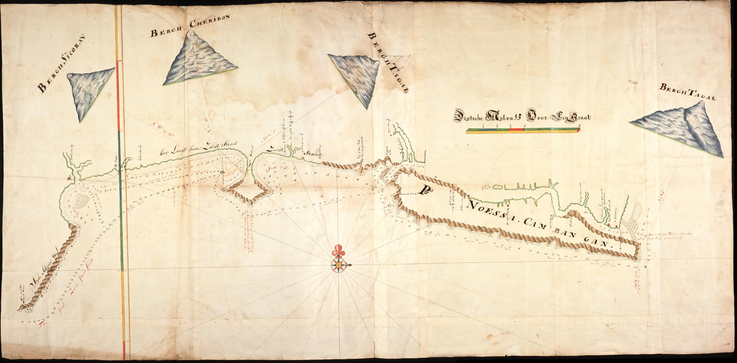
Nederlands: Titel catalogus Leupe (NA): Kaart als voren, van Een enkele dorre boom tot aan den mond van de rivier den Donau, hiermee wordt bedoeld de titel van VEL0436: Kaart van de zuidkust van Java....
Rechtsonder genummerd N 260. De afbeelding toont een kustlijn met beschrijvingen en plaatsnamen Stijle klippige Wal, hier Langs heen Zandt Strant, Swart Sandt, de Mont Sandt den donauw. Boven de kustlijn zijn bergen getekend Berh Sicoray, Bergh Cheribon, Bergh Tagal. Rechts is de schaalverdeling Duijtsche Mijlen 15 Voor Den Graat.English: Title in the Leupe catalogue (NA): Kaart als voren, van Een enkele dorre boom tot aan den mond van de rivier den Donau, referring to the title of VEL0436: Kaart van de zuidkust van Java....
Numbered bottom right N 260. The picture shows a coastline with descriptions and names of places Stijle klippige Wal, hier Langs heen Zandt Strant, Swart Sandt, de Mont Sandt den donauw. Above the coastline a number of mountains have been drawn Berh Sicoray, Bergh Cheribon, Bergh Tagal. On the right is the scale Duijtsche Mijlen 15 Voor Den Graat. |
|||||||||||||||||||||||
| Date | between 1700 and 1800 | |||||||||||||||||||||||
| Medium |
Nederlands: ingekleurde tekening op papier
English: coloured drawing on paper |
|||||||||||||||||||||||
| Dimensions | height: 165 cm (64.9 in); width: 80 cm (31.4 in) | |||||||||||||||||||||||
| Collection |
|
|||||||||||||||||||||||
| Accession number |
NL-HaNA_4.VEL_437 (old number: VEL0437) |
|||||||||||||||||||||||
| Inscriptions |
-
|
|||||||||||||||||||||||
| Notes |
English: Subjects: banderole / cartouche / ornamentation, chart / map / plan, compass / dial, building, house, flora
Nederlands: Onderwerpen: banderol / cartouche / versiering, plattegrond / kaart, kompas / windroos, gebouw, huis / woonhuis, flora |
|||||||||||||||||||||||
| Source/Photographer |
|
|||||||||||||||||||||||
| Permission (Reusing this file) |
|
|||||||||||||||||||||||

File history
Click on a date/time to view the file as it appeared at that time.
| Date/Time | Thumbnail | Dimensions | User | Comment | |
|---|---|---|---|---|---|
| current | 08:54, 11 June 2014 | | 2,400 × 1,183 (285 KB) | HuskyBot (talk | contribs) | == {{int:filedesc}} == {{Artwork |title = {{nl|1=Kaart van de zuidkust van Java}} {{en|1=Map of Java's southern coast}} |description = {{nl|1=Titel catalogus Leupe (NA): ''Kaart als voren, van Een enkele dorre... |
You cannot overwrite this file.
File usage on Commons
The following page uses this file: