File:AMH-7688-NA Floor plan of the Batenstein fort at Butri.jpg

Original file (2,400 × 1,772 pixels, file size: 308 KB, MIME type: image/jpeg)
Captions
Captions
Summary[edit]
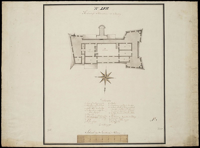
Nederlands: Plattegrond van het fort Batenstein te Butri
English: Floor plan of the Batenstein fort at Butri( |
||||||||||||||||||||||||
|---|---|---|---|---|---|---|---|---|---|---|---|---|---|---|---|---|---|---|---|---|---|---|---|---|
| Author |
Nederlands: Anoniem / Anonymous (landmeter / kaartenmaker)
English: Anoniem / Anonymous (land surveyor / mapmaker) |
|||||||||||||||||||||||
| Title |
Nederlands: Plattegrond van het fort Batenstein te Butri
English: Floor plan of the Batenstein fort at Butri |
|||||||||||||||||||||||
| Description |
Nederlands: Plattegrond van het fort Batenstein te Boutri.
Titel catalogus Leupe (NA): Het Fortress Badenstein tot Boutry. Het Fortress Badenstein tot Boutry. Notities verso: No. 18 reg. 8. / 455 [met vette cijfers gestempeld op een etiketje]. Middenboven: 17e LVII. Rechtsonder: No: 1. Linksonder en rechtsonder: 755 [in potlood]. Legenda: Declaratie / 1. Trap van de Berg in 't fort / 2. kleyn Pleinje voor de Schildwagt voor de poort / 3. klokken Huys, boven de Wagt / 4. De Wagt, waeraan westlijk het polver Magazijn / 5. Regen-bak / 6. Zaal van de Commandant, waeronder de Soldaeten logies / 7. Doorgang van deselve nae de battery / 8. Spintje / 9. Provisie Spintje / 10. Keuken / 11. Slaapkaamer, waeronder 't Slaeve Gat / 12. Een Zaal vand' Hr: I. Woortman gebouwt Anno 1777. waeronder de Woningen van de Sergeant, Corporaal en Constabel. / 13. Een kleyne Kaamer, waeronder de Milhio logie / 14. Een kaamer .... waeronder 't Pakhuys / 15. adsistenten Woning waeronder 't Pakhuys / 16. & 17. twee Schilder huysjes / 18. De Vlagge Stok.English: Floor plan of the Batenstein fort at Boutri.
Title in the Leupe catalogue (NA): Het Fortress Badenstein tot Boutry. Het Fortress Badenstein tot Boutry. Notes on reverse: No. 18 reg. 8. / 455 [stamped in bold on a small label]. Top centre: 17e LVII. Bottom right: No: 1. Bottom left and bottom right: 755 [in pencil]. Key: Declaratie / 1. Trap van de Berg in 't fort / 2. kleyn Pleinje voor de Schildwagt voor de poort / 3. klokken Huys, boven de Wagt / 4. De Wagt, waeraan westlijk het polver Magazijn / 5. Regen-bak / 6. Zaal van de Commandant, waeronder de Soldaeten logies / 7. Doorgang van deselve nae de battery / 8. Spintje / 9. Provisie Spintje / 10. Keuken / 11. Slaapkaamer, waeronder 't Slaeve Gat / 12. Een Zaal vand' Hr: I. Woortman gebouwt Anno 1777. waeronder de Woningen van de Sergeant, Corporaal en Constabel. / 13. Een kleyne Kaamer, waeronder de Milhio logie / 14. Een kaamer .... waeronder 't Pakhuys / 15. adsistenten Woning waeronder 't Pakhuys / 16. & 17. twee Schilder huysjes / 18. De Vlagge Stok. |
|||||||||||||||||||||||
| Date | 12 February 1791 | |||||||||||||||||||||||
| Medium |
Nederlands: pen en penseel op papier
English: pen and brush on paper |
|||||||||||||||||||||||
| Dimensions | height: 65.5 cm (25.7 in); width: 48.5 cm (19 in) | |||||||||||||||||||||||
| Collection |
|
|||||||||||||||||||||||
| Accession number |
NL-HaNA_4.VEL_755 (old number: VEL0755) |
|||||||||||||||||||||||
| Inscriptions |
Het Fortress Badenstein tot Boutry
|
|||||||||||||||||||||||
| Notes |
English: Subjects: chart / map / plan, key, compass / dial, powder magazine / powder mill, fortification, building, warehouse, tanck / well / watering hole, house
Nederlands: Onderwerpen: plattegrond / kaart, legenda, kompas / windroos, kruithuis / kruitmolen, vesting, gebouw, pakhuis, tanck / waterplaats / put, huis / woonhuis
English: Post: this image is related to a WIC trading post called Butri |
|||||||||||||||||||||||
| Source/Photographer |
|
|||||||||||||||||||||||
| Permission (Reusing this file) |
|
|||||||||||||||||||||||

| Object location | | View this and other nearby images on: OpenStreetMap |
|---|
File history
Click on a date/time to view the file as it appeared at that time.
| Date/Time | Thumbnail | Dimensions | User | Comment | |
|---|---|---|---|---|---|
| current | 10:08, 11 June 2014 | | 2,400 × 1,772 (308 KB) | HuskyBot (talk | contribs) | == {{int:filedesc}} == {{Artwork |title = {{nl|1=Plattegrond van het fort Batenstein te Butri}} {{en|1=Floor plan of the Batenstein fort at Butri}} |description = {{nl|1=Plattegrond van het fort Batenstein te B... |
You cannot overwrite this file.
File usage on Commons
The following page uses this file: