File:AMH-8619-NA Map of English and French colonial possessions in North America.jpg

Original file (2,400 × 1,784 pixels, file size: 565 KB, MIME type: image/jpeg)
Captions
Captions
Summary[edit]
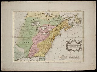
Nederlands: Kaart van de Engelse en Franse bezittingen in Noord Amerika
English: Map of English and French colonial possessions in North America( |
||||||||||||||||||||||||
|---|---|---|---|---|---|---|---|---|---|---|---|---|---|---|---|---|---|---|---|---|---|---|---|---|
| Author |
Nederlands: T. Kitchin (graveur / etser), Anoniem / Anonymous (landmeter / kaartenmaker)
English: T. Kitchin (engraver / etcher), Anoniem / Anonymous (land surveyor / mapmaker) |
|||||||||||||||||||||||
| Title |
Nederlands: Kaart van de Engelse en Franse bezittingen in Noord Amerika
English: Map of English and French colonial possessions in North America |
|||||||||||||||||||||||
| Description |
Nederlands: Kaart van de Engelse en Franse bezittingen in Noord Amerika.
Titel Catalogus Leupe (NA): Carte des possessions Angloises et Francoises du continent de L'Amerique Septentrionale. Carte des Possessions Angloises & Françoises du Continent de l'Amérique Septentrionale. Rechtsonder, in potlood: 1381. Cf. Nationaal Archief, Den Haag, inv. nr. 1381.English: Map of English and French colonial possessions in North America.
Title in the Leupe Catalogue (NA): Carte des possessions Angloises et Francoises du continent de L'Amerique Septentrionale. Carte des Possessions Angloises & Françoises du Continent de l'Amérique Septentrionale. Bottom right, in pencil: 1381. Cf. Nationaal Archives, The Hague, inv. nr. 1381. |
|||||||||||||||||||||||
| Date | 1755 | |||||||||||||||||||||||
| Medium |
Nederlands: koperdruk op papier
English: copperplate printing on paper |
|||||||||||||||||||||||
| Dimensions | height: 57.3 cm (22.5 in); width: 77.7 cm (30.5 in) | |||||||||||||||||||||||
| Collection |
|
|||||||||||||||||||||||
| Accession number |
NL-HaNA_4.VEL_1381 (old number: VEL1381) |
|||||||||||||||||||||||
| Inscriptions |
Carte des Possessions Angloises & Françoises du Continent de l'Amérique Septentrionale
author: Th. Kitchin, sculp. in London for a French edition of Atlas methodique by Jean Palairet |
|||||||||||||||||||||||
| Notes |
English: Subjects: chart / map / plan, banderole / cartouche / ornamentation
Nederlands: Onderwerpen: plattegrond / kaart, banderol / cartouche / versiering
English: Post: this image is related to a WIC trading post called New York |
|||||||||||||||||||||||
| Source/Photographer |
|
|||||||||||||||||||||||
| Permission (Reusing this file) |
|
|||||||||||||||||||||||

| Object location | | View this and other nearby images on: OpenStreetMap |
|---|
File history
Click on a date/time to view the file as it appeared at that time.
| Date/Time | Thumbnail | Dimensions | User | Comment | |
|---|---|---|---|---|---|
| current | 10:28, 11 June 2014 | | 2,400 × 1,784 (565 KB) | HuskyBot (talk | contribs) | == {{int:filedesc}} == {{Artwork |title = {{nl|1=Kaart van de Engelse en Franse bezittingen in Noord Amerika}} {{en|1=Map of English and French colonial possessions in North America}} |description = {{nl|1=Kaar... |
You cannot overwrite this file.
File usage on Commons
The following page uses this file: