File:AMSRE Sea Ice Extent.png
Jump to navigation
Jump to search
No higher resolution available.
AMSRE_Sea_Ice_Extent.png (720 × 450 pixels, file size: 100 KB, MIME type: image/png)
Captions
Captions
Add a one-line explanation of what this file represents
Summary
[edit]
| Description |
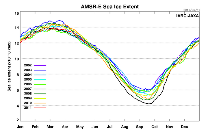
日本語: 海氷面積の変化(2002年6月~)
|
| Date | |
| Source | 海氷面積の変化(2002年6月~) |
| Author | 宇宙航空研究開発機構(JAXA) |
Licensing
[edit]
| This work is ineligible for copyright and therefore in the public domain because it consists entirely of information that is common property and contains no original authorship. |
File history
Click on a date/time to view the file as it appeared at that time.
| Date/Time | Thumbnail | Dimensions | User | Comment | |
|---|---|---|---|---|---|
| current | 05:22, 17 May 2011 | | 720 × 450 (100 KB) | Masa555 (talk | contribs) | {{Information |Description ={{ja|1=海氷面積の変化(2002年6月~)}} |Source =宇宙航空研究開発機構(JAXA) |Author =宇宙航空研究開発機構(JAXA) |Date =2011年5月15日 |Permission = |othe |
You cannot overwrite this file.
File usage on Commons
There are no pages that use this file.