File:A plat of all the world - Norman B. Leventhal Map Center at the BPL.jpg
Jump to navigation
Jump to search

Size of this preview: 800 × 537 pixels. Other resolutions: 320 × 215 pixels | 640 × 430 pixels | 1,024 × 688 pixels | 1,280 × 860 pixels | 2,000 × 1,343 pixels.
Original file (2,000 × 1,343 pixels, file size: 2.37 MB, MIME type: image/jpeg)
Captions
Captions
Add a one-line explanation of what this file represents
Summary[edit]
| Description |
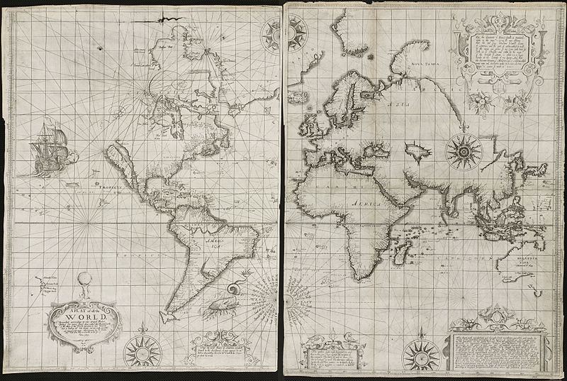
Zoom into this map at maps.bpl.org. Author: Wright, Edward Publisher: Joseph Moxon Date: [1657], 1655.
BPL Call Number: G3200 1657.W7 View at the Norman B. Leventhal Map Center
|
| Date | |
| Source | A plat of all the world |
| Author | http://maps.bpl.org |
Licensing[edit]
This file is licensed under the Creative Commons Attribution 2.0 Generic license.
- You are free:
- to share – to copy, distribute and transmit the work
- to remix – to adapt the work
- Under the following conditions:
- attribution – You must give appropriate credit, provide a link to the license, and indicate if changes were made. You may do so in any reasonable manner, but not in any way that suggests the licensor endorses you or your use.
| This image was originally posted to Flickr by Norman B. Leventhal Map Center at the BPL at https://www.flickr.com/photos/24528911@N05/2709980753. It was reviewed on 2 July 2012 by FlickreviewR and was confirmed to be licensed under the terms of the cc-by-2.0. |
File history
Click on a date/time to view the file as it appeared at that time.
| Date/Time | Thumbnail | Dimensions | User | Comment | |
|---|---|---|---|---|---|
| current | 01:42, 2 July 2012 | | 2,000 × 1,343 (2.37 MB) | Dzlinker (talk | contribs) | == {{int:filedesc}} == {{Information |Description=Zoom into [http://maps.bpl.org/id/M8788/ this map] at [http://maps.bpl.org maps.bpl.org]. '''Author:''' Wright, Edward '''Publisher:''' Joseph Moxon '''Date:''' [1657], 1655. '''Scale:''' Scale not gi... |
You cannot overwrite this file.
File usage on Commons
There are no pages that use this file.
File usage on other wikis
The following other wikis use this file: