File:A water dam in the village of Bin al-Ouedan.jpg
Jump to navigation
Jump to search

Size of this preview: 800 × 450 pixels. Other resolutions: 320 × 180 pixels | 640 × 360 pixels | 1,024 × 576 pixels | 1,280 × 720 pixels | 2,560 × 1,440 pixels | 6,544 × 3,680 pixels.
Original file (6,544 × 3,680 pixels, file size: 3.26 MB, MIME type: image/jpeg)
Captions
Captions
Add a one-line explanation of what this file represents
Summary[edit]
| Description |
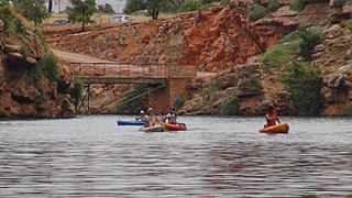
English: A water dam in the village of Bin al-Ouedan in the province of Azilal also, about 30 km away from Azilal, designed by André Quinn, was built during the colonial period in 1953 and built in a very high way to produce energy and irrigation. It is the largest arc-shaped dam on the African continent and also the largest in terms of energy production. It includes a lake of tranquility and a beautiful atmosphere for tourists to swim, snorkel, catch, ride bicycles and watercraft.
Ab: Una presa de agua en la aldea de Bin al-Ouedan en la provincia de Azilal también, a unos 30 km de distancia de Azilal, diseñada por André Quinn, fue construida durante el período colonial en 1953 y construida en una forma muy alta para producir energía y riego. Es la presa más grande en forma de arco en el continente africano y también la más grande en términos de producción de energía. Incluye un lago de tranquilidad y una hermosa atmósfera para que los turistas naden, buceen, atrapen, anden en bicicleta y motos de agua.
Français : Un barrage d'eau dans le village de Bin al-Ouedan dans la province d'Azilal également, à environ 30 km d'Azilal, conçu par André Quinn, a été construit pendant la période coloniale en 1953 et construit de manière très élevée pour produire de l'énergie et de l'irrigation. C'est le plus grand barrage en forme d'arc sur le continent africain et le plus grand en termes de production d'énergie.Il comprend un lac de tranquillité et une belle atmosphère pour les touristes de nager, faire de la plongée, prendre des vélos et des embarcations. |
| Date | |
| Source | Own work |
| Author | Sky139 |
| Camera location | | View this and other nearby images on: OpenStreetMap |
|---|
Licensing[edit]
I, the copyright holder of this work, hereby publish it under the following license:
This file is licensed under the Creative Commons Attribution-Share Alike 4.0 International license.
- You are free:
- to share – to copy, distribute and transmit the work
- to remix – to adapt the work
- Under the following conditions:
- attribution – You must give appropriate credit, provide a link to the license, and indicate if changes were made. You may do so in any reasonable manner, but not in any way that suggests the licensor endorses you or your use.
- share alike – If you remix, transform, or build upon the material, you must distribute your contributions under the same or compatible license as the original.
This image was uploaded as part of Wiki Loves Earth 2018.
|
 |
File history
Click on a date/time to view the file as it appeared at that time.
| Date/Time | Thumbnail | Dimensions | User | Comment | |
|---|---|---|---|---|---|
| current | 17:12, 25 June 2018 | | 6,544 × 3,680 (3.26 MB) | Sky139 (talk | contribs) | User created page with UploadWizard |
You cannot overwrite this file.
File usage on Commons
There are no pages that use this file.