File:Aerial View of the Lamar Site (e3053e33-1dd8-b71b-0b6f-ec24c2691c63).jpg
Jump to navigation
Jump to search

Size of this preview: 800 × 533 pixels. Other resolutions: 320 × 213 pixels | 640 × 427 pixels.
Original file (900 × 600 pixels, file size: 133 KB, MIME type: image/jpeg)
Captions
Captions
Add a one-line explanation of what this file represents

|
The categories of this image need checking. You can do so here.
|
.jpg&action=edit&withJS=MediaWiki:Catcheck.js)
Summary
[edit].jpg&action=edit§ion=1)
| English: Aerial View of the Lamar Site | ||||
|---|---|---|---|---|
| Photographer |
English: NPS |
|||
| Title |
English: Aerial View of the Lamar Site |
|||
| Publisher |
English: U.S. National Park Service |
|||
| Description |
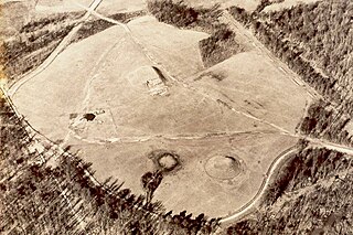
English: An aerial photo showing the open field where two mounds are surrounded by woods. 1930's photo of the Lamar Mounds.
|
|||
| Depicted place |
English: Ocmulgee Mounds National Historical Park, Bibb County, Georgia |
|||
| Accession number | ||||
| Source |
English: NPGallery |
|||
| Permission (Reusing this file) |
|
|||
| NPS Unit Code | OCMU | |||
| Album(s) | English: Historic Photos |
|||
File history
Click on a date/time to view the file as it appeared at that time.
| Date/Time | Thumbnail | Dimensions | User | Comment | |
|---|---|---|---|---|---|
| current | 20:37, 15 May 2024 | | 900 × 600 (133 KB) | BMacZeroBot (talk | contribs) | Batch upload (Commons:Batch uploading/NPGallery) |
You cannot overwrite this file.
File usage on Commons
There are no pages that use this file.
.jpg&oldid=876661800)