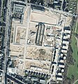
File:Aerial view Clouth quarter construction spring 2016.jpg
From Wikimedia Commons, the free media repository
Jump to navigation
Jump to search

Size of this preview: 467 × 599 pixels. Other resolutions: 187 × 240 pixels | 374 × 480 pixels | 598 × 768 pixels | 798 × 1,024 pixels | 1,596 × 2,048 pixels | 4,620 × 5,928 pixels.
Original file (4,620 × 5,928 pixels, file size: 10.52 MB, MIME type: image/jpeg)
File information
Structured data
Captions
Captions
Aerial view of constructions works on Clouth area in spring 2016
Luftbild der Bauarbeiten auf dem Clouth Gelände im Frühjahr 2016
| Object location | 50° 57′ 55.27″ N, 6° 57′ 41.35″ E | View this and other nearby images on: OpenStreetMap |
|---|
Summary[edit]
| DescriptionAerial view Clouth quarter construction spring 2016.jpg |
Deutsch: Luftbild der Bauarbeiten auf dem Clouth Gelände im Frühjahr 2016. Auflösung 0,1 m pro Pixel.
English: Aerial view of constructions works on Clouth area in spring 2016. Resolution 0.1 m per pixel. |
| Date | |
| Source |
Land NRW (2018)
Datenlizenz Deutschland -Namensnennung - Version 2.0 ([1])
Bezirksregierung Köln, Geobasis NRW, 50606 Köln |
| Author | Original aerial image from Land NRW, Bezirksregierung Köln. Image composed from four tiles and cropped, showing Clouth area in Summer 2016. Composition by Dr. Schorsch (talk) 15:00, April 3, 2021 (UTC) |
| Permission (Reusing this file) |
[Original permission https://www.bezreg-koeln.nrw.de/brk_internet/geobasis/lizenzbedingungen_geobasis_nrw.pdf] |
| Other versions |
|
| Geotemporal data | ||||||||||
| Bounding box |
|
|||||||||
| Georeferencing | View the georeferenced map in the Wikimaps Warper | |||||||||
Licensing[edit]

|
This file is licensed under the terms of the Data licence Germany – attribution – version 2.0 |
|
You are free:
Under the following conditions:
|
File history
Click on a date/time to view the file as it appeared at that time.
| Date/Time | Thumbnail | Dimensions | User | Comment | |
|---|---|---|---|---|---|
| current | 13:13, 3 April 2021 |  | 4,620 × 5,928 (10.52 MB) | Xorx (talk | contribs) | Higher resolution, higher quality image created from 4 original tiff images with 10000x10000 pixel resolution each |
| 20:39, 12 November 2018 |  | 1,199 × 1,286 (763 KB) | Xorx (talk | contribs) | User created page with UploadWizard |
You cannot overwrite this file.
File usage on Commons
The following 5 pages use this file:
File usage on other wikis
The following other wikis use this file:
- Usage on de.wikipedia.org
- Usage on en.wikipedia.org
- Usage on www.wikidata.org


