File:Afghanistan physisch.png
Jump to navigation
Jump to search

Size of this preview: 768 × 599 pixels. Other resolutions: 308 × 240 pixels | 615 × 480 pixels | 984 × 768 pixels | 1,280 × 999 pixels | 1,622 × 1,266 pixels.
Original file (1,622 × 1,266 pixels, file size: 3.26 MB, MIME type: image/png)
Captions
Captions
Add a one-line explanation of what this file represents
Summary[edit]
| Description |
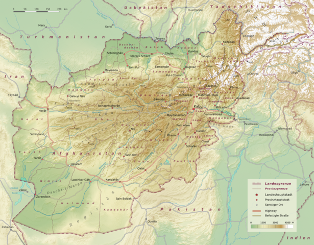
Deutsch: Physische Karte Afghanistan, administrative Gliederung in 34 Provinzen gemäß der Verwaltungsreform von 2005. |
| Date | |
| Source | Selbst erstellt, verwendeter topographischer Datensatz: SRTM30 V2.1 |
| Author | Benutzer:Sommerkom |
| Other versions |
|

Licensing[edit]
Sommerkom at German Wikipedia, the copyright holder of this work, hereby publishes it under the following licenses:

|
Permission is granted to copy, distribute and/or modify this document under the terms of the GNU Free Documentation License, Version 1.2 or any later version published by the Free Software Foundation; with no Invariant Sections, no Front-Cover Texts, and no Back-Cover Texts. A copy of the license is included in the section entitled GNU Free Documentation License. |
This file is licensed under the Creative Commons Attribution-Share Alike 3.0 Unported license.
Attribution: Sommerkom at German Wikipedia
- You are free:
- to share – to copy, distribute and transmit the work
- to remix – to adapt the work
- Under the following conditions:
- attribution – You must give appropriate credit, provide a link to the license, and indicate if changes were made. You may do so in any reasonable manner, but not in any way that suggests the licensor endorses you or your use.
- share alike – If you remix, transform, or build upon the material, you must distribute your contributions under the same or compatible license as the original.
This file is licensed under the Creative Commons Attribution-Share Alike 3.0 Germany license.
Attribution: Sommerkom at German Wikipedia
- You are free:
- to share – to copy, distribute and transmit the work
- to remix – to adapt the work
- Under the following conditions:
- attribution – You must give appropriate credit, provide a link to the license, and indicate if changes were made. You may do so in any reasonable manner, but not in any way that suggests the licensor endorses you or your use.
- share alike – If you remix, transform, or build upon the material, you must distribute your contributions under the same or compatible license as the original.

You may select the license of your choice.
Original upload log[edit]
Transferred from de.wikipedia to Commons by NordNordWest using CommonsHelper.
The original description page was here. All following user names refer to de.wikipedia.
- 2009-10-11 12:56 Sommerkom 1622×1266× (3415723 bytes) {{Information |Beschreibung = |Quelle = |Urheber = |Datum = |Genehmigung = |Andere Versionen = |Anmerkungen = }}
- 2009-10-11 12:26 Sommerkom 1622×1266× (3414682 bytes) {{Information |Beschreibung = |Quelle = |Urheber = |Datum = |Genehmigung = |Andere Versionen = |Anmerkungen = }}
- 2009-10-10 17:36 Sommerkom 1559×1218× (3196619 bytes) {{Information |Beschreibung = |Quelle = |Urheber = |Datum = |Genehmigung = |Andere Versionen = |Anmerkungen = }}
- 2009-10-09 16:36 Sommerkom 1455×1137× (2625655 bytes) {{Information |Beschreibung = Physische Karte Afghanistan, administrative Gliederung in 34 Provinzen gemäß der Verwaltungsreform von 2005. |Quelle = Selbst erstellt, verwendeter topographischer Datensatz: [http://www2.jpl.nasa.gov/srtm/index.html SRTM30
File history
Click on a date/time to view the file as it appeared at that time.
| Date/Time | Thumbnail | Dimensions | User | Comment | |
|---|---|---|---|---|---|
| current | 10:02, 17 September 2010 | | 1,622 × 1,266 (3.26 MB) | File Upload Bot (Magnus Manske) (talk | contribs) | {{BotMoveToCommons|de.wikipedia|year={{subst:CURRENTYEAR}}|month={{subst:CURRENTMONTHNAME}}|day={{subst:CURRENTDAY}}}} {{Information |Description={{de|Physische Karte Afghanistan, administrative Gliederung in 34 Provinzen gemäß der Verwaltungsreform vo |
You cannot overwrite this file.
File usage on Commons
The following page uses this file:
File usage on other wikis
The following other wikis use this file:
- Usage on de.wikipedia.org
- Afghanistan
- Wikipedia:Kartenwerkstatt/Archiv/2009-10
- Benutzer:Uwe Dedering/Länderliste
- Wikipedia Diskussion:Hauptseite/Artikel des Tages/Archiv/Vorschläge/2012/2
- Wikipedia Diskussion:Hauptseite/Artikel des Tages/Archiv/Vorschläge/2013/Q3
- Wikipedia Diskussion:Hauptseite/Artikel des Tages/Archiv/Vorschläge/2014/Q3
- Wikipedia:Hauptseite/Archiv/29. September 2014
- Usage on hu.wikipedia.org
- Usage on sq.wikinews.org