File:Aliyah numbers by country.svg
(Redirected from File:Aliyahnumbersby country.svg)

Size of this PNG preview of this SVG file: 744 × 387 pixels. Other resolutions: 320 × 166 pixels | 640 × 333 pixels | 1,024 × 533 pixels | 1,280 × 666 pixels | 2,560 × 1,332 pixels.
Original file (SVG file, nominally 744 × 387 pixels, file size: 2.09 MB)
Captions
Captions
Add a one-line explanation of what this file represents
Summary[edit]
| Description |
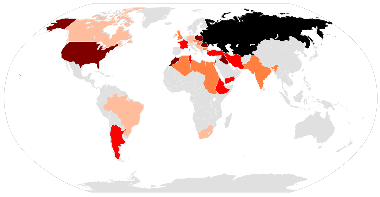
English: A map of cumulative aliyah numbers by country or region (from 1882/1919/1948 to 2010
Israel = Blue,Over 400,000 = Black, 100,000-399,999 = Brown, 50,000-99,999, Orange = 20,000-49,999, Light orange = 10,000-19,999, Gray = 9,999 or less |
||
| Date | (UTC) | ||
| Source |
This file was derived from: BlankMap-World 1959.svg: |
||
| Author |
|
||
| SVG development |
|

Licensing[edit]
I, the copyright holder of this work, hereby publish it under the following licenses:
This file is licensed under the Creative Commons Attribution-Share Alike 3.0 Unported, 2.5 Generic, 2.0 Generic and 1.0 Generic license.
- You are free:
- to share – to copy, distribute and transmit the work
- to remix – to adapt the work
- Under the following conditions:
- attribution – You must give appropriate credit, provide a link to the license, and indicate if changes were made. You may do so in any reasonable manner, but not in any way that suggests the licensor endorses you or your use.
- share alike – If you remix, transform, or build upon the material, you must distribute your contributions under the same or compatible license as the original.

|
Permission is granted to copy, distribute and/or modify this document under the terms of the GNU Free Documentation License, Version 1.2 or any later version published by the Free Software Foundation; with no Invariant Sections, no Front-Cover Texts, and no Back-Cover Texts. A copy of the license is included in the section entitled GNU Free Documentation License. |
You may select the license of your choice.
Original upload log[edit]
This image is a derivative work of the following images:
- File:BlankMap-World_1959.svg licensed with Cc-by-sa-3.0,2.5,2.0,1.0, GFDL
- 2008-05-25T08:14:01Z Sémhur 940x477 (812289 Bytes) Group Pakistan and East-Pakistan (not yet Bangladesh in 1959)
- 2008-04-14T17:16:36Z Sémhur 940x477 (812178 Bytes) the bitmap... one more time
- 2008-04-14T17:10:41Z Sémhur 940x477 (812859 Bytes) {{Information |Description= {{en|SVG Blank map of the world showing 1959 borders.}} {{fr|Carte muette du monde montrant les frontières de 1959, au format SVG.}} |Source= * [[:Image:BlankMap-World6.svg]] by {{u|Canuckguy}}, u
Uploaded with derivativeFX
File history
Click on a date/time to view the file as it appeared at that time.
| Date/Time | Thumbnail | Dimensions | User | Comment | |
|---|---|---|---|---|---|
| current | 22:57, 11 September 2012 | | 744 × 387 (2.09 MB) | AnonMoos (talk | contribs) | adjust margins |
| 05:21, 26 July 2012 |  | 744 × 1,052 (2.1 MB) | Futurist110 (talk | contribs) | Nothing much | |
| 05:08, 26 July 2012 |  | 744 × 1,052 (2 MB) | Futurist110 (talk | contribs) | Clearing up the map | |
| 04:50, 26 July 2012 |  | 744 × 1,052 (1.88 MB) | Futurist110 (talk | contribs) | Nicer map | |
| 04:46, 26 July 2012 |  | 744 × 1,052 (1.88 MB) | Futurist110 (talk | contribs) | Better map | |
| 02:54, 26 July 2012 |  | 744 × 1,052 (1.79 MB) | Futurist110 (talk | contribs) | Corrected error on Yemen | |
| 02:49, 26 July 2012 |  | 744 × 1,052 (1.77 MB) | Futurist110 (talk | contribs) | Clearer map | |
| 02:37, 26 July 2012 |  | 744 × 1,052 (1.76 MB) | Futurist110 (talk | contribs) | == {{int:filedesc}} == {{Information |Description={{en|SVG Blank map of the world showing 1959 borders.}} {{fr|Carte muette du monde montrant les frontières de 1959, au format SVG.}} |Source={{Derived from|BlankMap-World_1959.svg|display=50}} |Date=20... |
You cannot overwrite this file.
File usage on Commons
The following page uses this file:
- File:Aliyahnumbersby country.svg (file redirect)