File:Anachronous map of the All French Empire (1534 -1970)-ar.png
Jump to navigation
Jump to search

Size of this preview: 800 × 406 pixels. Other resolutions: 320 × 162 pixels | 640 × 325 pixels | 1,024 × 520 pixels | 2,000 × 1,015 pixels.
Original file (2,000 × 1,015 pixels, file size: 381 KB, MIME type: image/png)
Captions
Captions
Add a one-line explanation of what this file represents
Summary[edit]
-ar.png&action=edit§ion=1)
| Description |
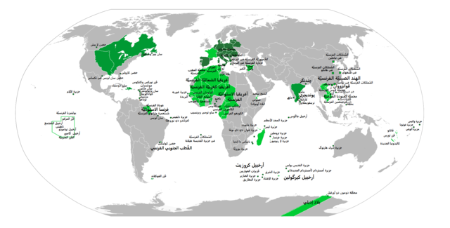
العربية: خريطة الإمبراطوريَّة الفرنسيَّة. اللون الأخضر الغامق يُشيرُ إلى مناطق سيطرة ونُفوذ الإمبراطوريَّة الفرنسيَّة الاستعماريَّة الأولى (حُدود تقريبيَّة)، أمَّا اللون الأخضر الفاتح فيُشير إلى المناطق التي خضعت لِلإمبراطوريَّة الفرنسيَّة الاستعماريَّة الثانية. |
| Date | |
| Source |
This file was derived from: Anachronous map of the All French Empire (1534 -1970).png |
| Author |
|
| Other versions | English |
.png)
| This is a retouched picture, which means that it has been digitally altered from its original version. Modifications: Translated to Arabic - عُرِبَت. The original can be viewed here: Anachronous map of the All French Empire (1534 -1970).png:
|
Licensing[edit]
-ar.png&action=edit§ion=2)
| I, the copyright holder of this work, release this work into the public domain. This applies worldwide. In some countries this may not be legally possible; if so: I grant anyone the right to use this work for any purpose, without any conditions, unless such conditions are required by law. |
File history
Click on a date/time to view the file as it appeared at that time.
| Date/Time | Thumbnail | Dimensions | User | Comment | |
|---|---|---|---|---|---|
| current | 05:21, 28 June 2017 | | 2,000 × 1,015 (381 KB) | باسم (talk | contribs) | Removed Background - إزالة خلفيَّة الصُورة |
| 22:25, 27 June 2017 |  | 2,000 × 1,015 (341 KB) | باسم (talk | contribs) | User created page with UploadWizard |
You cannot overwrite this file.
File usage on Commons
There are no pages that use this file.
File usage on other wikis
The following other wikis use this file:
- Usage on ar.wikipedia.org
-ar.png&oldid=791798340)