File:Anatolia Ancient Regions ID.png
Jump to navigation
Jump to search
No higher resolution available.
Anatolia_Ancient_Regions_ID.png (800 × 518 pixels, file size: 95 KB, MIME type: image/png)
Captions
Captions
Add a one-line explanation of what this file represents
Summary[edit]
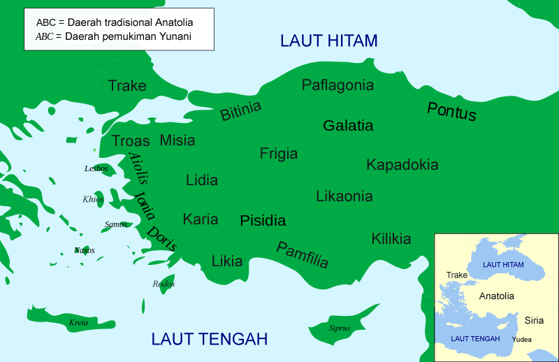
| Description | English: Political map of Asia Minor in 500 BC |
| Source | |
| Author | JohnThorne (talk) |
| Other versions |
[]
|


.svg)


Licensing[edit]
| I, the copyright holder of this work, release this work into the public domain. This applies worldwide. In some countries this may not be legally possible; if so: I grant anyone the right to use this work for any purpose, without any conditions, unless such conditions are required by law. |
File history
Click on a date/time to view the file as it appeared at that time.
| Date/Time | Thumbnail | Dimensions | User | Comment | |
|---|---|---|---|---|---|
| current | 16:29, 13 November 2013 | | 800 × 518 (95 KB) | JohnThorne (talk | contribs) | Perbaikan nama dan tambahan label |
| 16:28, 13 November 2013 |  | 800 × 518 (92 KB) | JohnThorne (talk | contribs) | Perbaikan nama | |
| 16:25, 13 November 2013 |  | 800 × 518 (92 KB) | JohnThorne (talk | contribs) | Perbaikan ejaan nama | |
| 21:36, 12 November 2013 |  | 800 × 518 (92 KB) | JohnThorne (talk | contribs) | Perubahan nama Aeolis menjadi Aiolis | |
| 21:15, 12 November 2013 |  | 800 × 518 (93 KB) | JohnThorne (talk | contribs) | English: Political map of Asia Minor in 500 BC Sumber: Asia_Minor_Political_500BC.svg |
You cannot overwrite this file.
File usage on Commons
The following 18 pages use this file:
- File:AnatoliaAncientRegions.png
- File:Anatolia Ancient Regions ID.png
- File:Map Anatolia ancient regions-af.jpg
- File:Map Anatolia ancient regions-el.svg
- File:Map Anatolia ancient regions-en.svg
- File:Map Anatolia ancient regions-es.svg
- File:Map Anatolia ancient regions-hu.svg
- File:Map Anatolia ancient regions-it.svg
- File:Map Anatolia ancient regions-mk.svg
- File:Map Anatolia ancient regions-pt.svg
- File:Map Anatolia ancient regions-ru.png
- File:Map Anatolia ancient regions-ru.svg
- File:Map Anatolia ancient regions-sl.svg
- File:Map Anatolia ancient regions-uk.svg
- File:Map Anatolia ancient regions-zh.svg
- File:Map Anatolia ancient regions (Indonesian version).svg
- File:مناطق آناتولی باستان.svg
- Template:Other versions/Map Anatolia ancient regions
File usage on other wikis
The following other wikis use this file: