File:Anschlussbahn Doberschütz Röcknitz Karte.jpg
Jump to navigation
Jump to search

Size of this preview: 668 × 599 pixels. Other resolutions: 268 × 240 pixels | 535 × 480 pixels | 856 × 768 pixels | 1,141 × 1,024 pixels | 2,286 × 2,051 pixels.
Original file (2,286 × 2,051 pixels, file size: 973 KB, MIME type: image/jpeg)
Captions
Captions
Add a one-line explanation of what this file represents
Summary[edit]
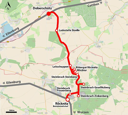
| Description | Übersichtskarte der ehemaligen Anschlussbahn Doberschütz–Röcknitz zum Zeitpunkt ihrer maximalen Ausdehnung 1927 | |||||||||||||
| Date | ||||||||||||||
| Source |
Own work
|
|||||||||||||
| Author | Joeb07 |
File history
Click on a date/time to view the file as it appeared at that time.
| Date/Time | Thumbnail | Dimensions | User | Comment | |
|---|---|---|---|---|---|
| current | 18:17, 13 July 2023 | | 2,286 × 2,051 (973 KB) | Joeb07 (talk | contribs) | {{Information |Description=Übersichtskarte der ehemaligen Anschlussbahn Doberschütz–Röcknitz zum Zeitpunkt ihrer maximalen Ausdehnung 1927 |Source={{own}}<br/>* Karte von {{OpenStreetMap}} |Date=13.07.2023 |Author={{User:Joeb07/Urheber}} |Permission= |other_versions= }} Category:Files by User:Joeb07 Category:Rail transport maps of Saxony Category:Rail transport maps of Prussia Category:Transport in Landkreis Nordsachsen Category:Transport in Landkreis Leipzig |
You cannot overwrite this file.
File usage on Commons
The following 3 pages use this file:
File usage on other wikis
The following other wikis use this file:
- Usage on de.wikipedia.org