File:Arbutus unedo (49106840476).jpg

Original file (2,048 × 1,365 pixels, file size: 2.6 MB, MIME type: image/jpeg)
Captions
Captions
Summary[edit]
.jpg&action=edit§ion=1)
| Description |
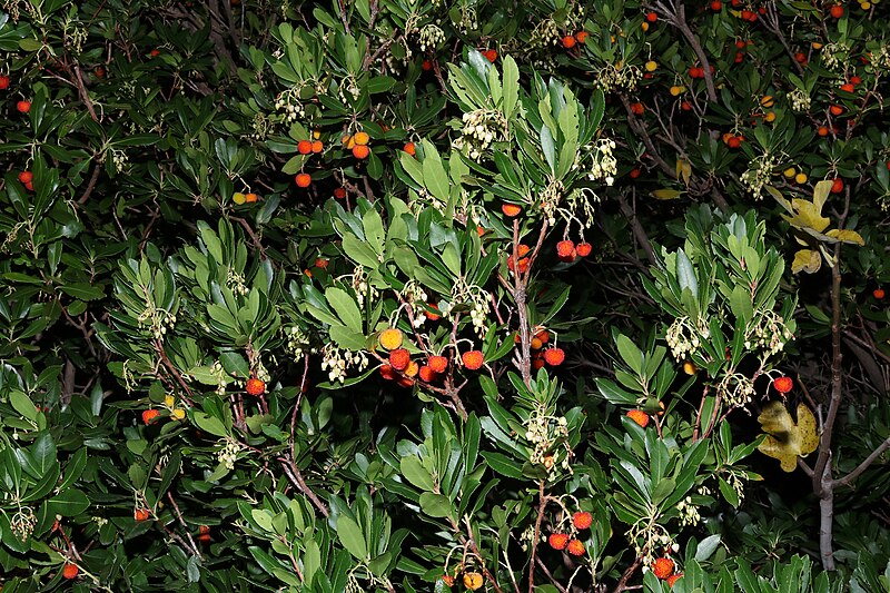
Familia: Ericaceae Juss. Subfamilia: Arbutoideae Nyman Species: Arbutus unedo L. Original publication details: Sp. Pl.: 395 (1753). Synonyms: Arbutus cassinifolia Steud.; Arbutus crispa Hoffmanns.; Arbutus integrifolia Sims; Arbutus intermedia Heldr. ex Nyman; Arbutus nothocomaros Heldr. ex Nyman; Arbutus pavarii Pamp.; Arbutus procumbens Kluk ex Besser; Arbutus salicifolia (Lodd.) Cels ex Hoffmanns.; Arbutus serratifolia Salisb.; Arbutus turbinata Pers. ex Rchb.; Arbutus vulgaris Bubani Common names: Corbezzolo (IT); Strawberry-tree (EN). Location: Valle Arenon (Municipality of Varazze, SV, LIG, IT). Elevation: 185 m (605 ft). Date: November 17, 2019. Status: native. Chorotype: Mediterranean-Atlantic. Note: the Strawberry-tree (Arbutus unedo L.) is a native species of the Mediterranean coasts of north-western Africa, of Europe and of Turkey and of the Atlantic coasts from Morocco to north-western France (Brittany). It is also native to some areas of Lebanon, Libya (Cyrenaica), to the Bulgarian and Turkish coasts of the Black Sea and to western Ireland. In Italy it is very frequent in all coastal areas from Liguria to Marche, while it is present, in a very fragmented way, in the Po basin, in the Adige basin and in Veneto, where it grows in few hilly areas that have sub-Mediterranean climate (eg Lake Garda, Euganean Hills, Romagna hills). In Liguria Arbutus unedo L. is widespread and very frequent in the coastal strip and in the sublittoral zone, it is rare in interland and absent in the valleys of the Po side. |
| Date | Taken on 17 November 2019, 13:46 |
| Source | Arbutus unedo |
| Author | Umberto Ferrando |
| Camera location | | View this and other nearby images on: OpenStreetMap |
|---|
.jpg¶ms=044.387780_N_0008.601050_E_globe:Earth_type:camera_source:Flickr_&language=en)
Licensing[edit]
.jpg&action=edit§ion=2)
- You are free:
- to share – to copy, distribute and transmit the work
- to remix – to adapt the work
- Under the following conditions:
- attribution – You must give appropriate credit, provide a link to the license, and indicate if changes were made. You may do so in any reasonable manner, but not in any way that suggests the licensor endorses you or your use.
| This image was originally posted to Flickr by ferrando.umberto at https://flickr.com/photos/185593532@N03/49106840476 (archive). It was reviewed on 26 November 2019 by FlickreviewR 2 and was confirmed to be licensed under the terms of the cc-by-2.0. |
File history
Click on a date/time to view the file as it appeared at that time.
| Date/Time | Thumbnail | Dimensions | User | Comment | |
|---|---|---|---|---|---|
| current | 01:31, 26 November 2019 | | 2,048 × 1,365 (2.6 MB) | Ser Amantio di Nicolao (talk | contribs) | Transferred from Flickr via #flickr2commons |
You cannot overwrite this file.
File usage on Commons
The following page uses this file:
- File:Arbutus unedo L. (49106840476).jpg (file redirect)
.jpg&redirect=no)
File usage on other wikis
The following other wikis use this file:
- Usage on en.wikipedia.org
.jpg&oldid=863221820)