File:Armenian Genocide Map-id.svg
Jump to navigation
Jump to search

Size of this PNG preview of this SVG file: 800 × 393 pixels. Other resolutions: 320 × 157 pixels | 640 × 314 pixels | 1,024 × 503 pixels | 1,280 × 629 pixels | 2,560 × 1,257 pixels | 2,574 × 1,264 pixels.
Original file (SVG file, nominally 2,574 × 1,264 pixels, file size: 463 KB)
Captions
Captions
Add a one-line explanation of what this file represents
Summary[edit]
| Description |
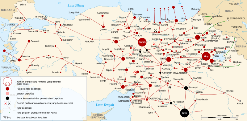
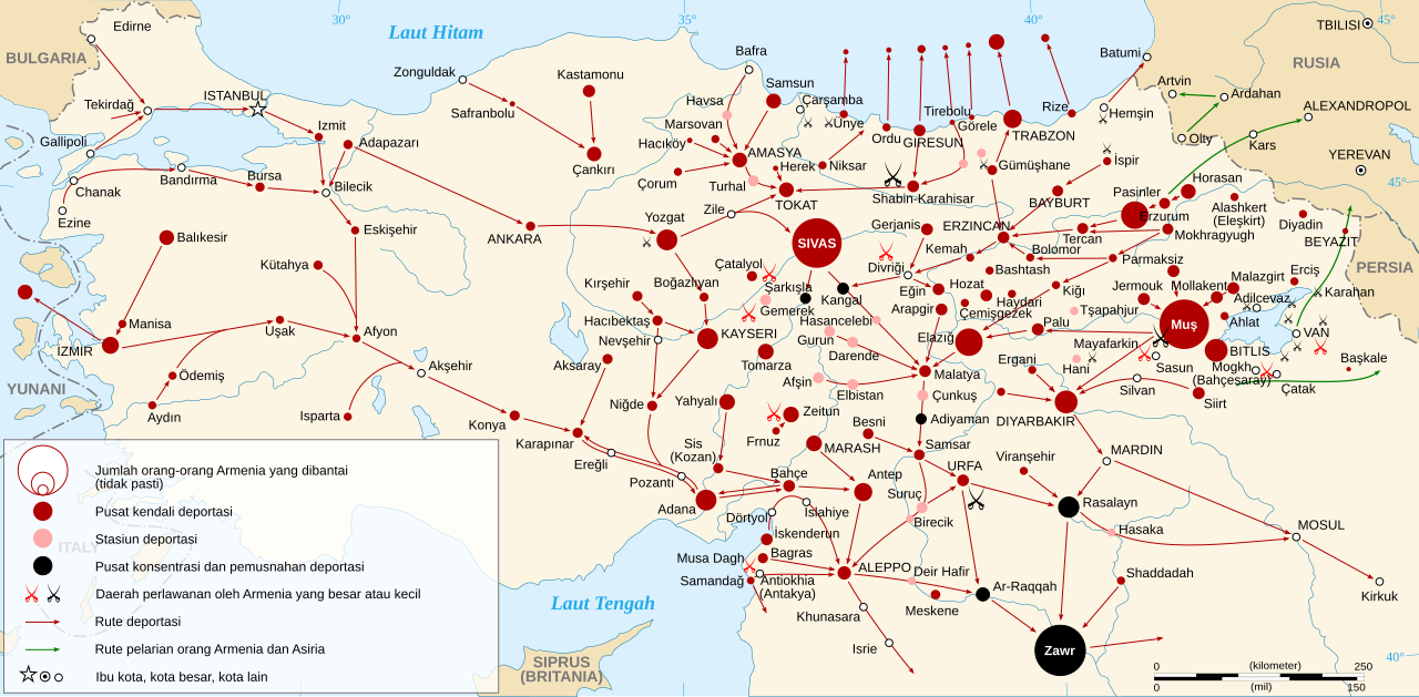
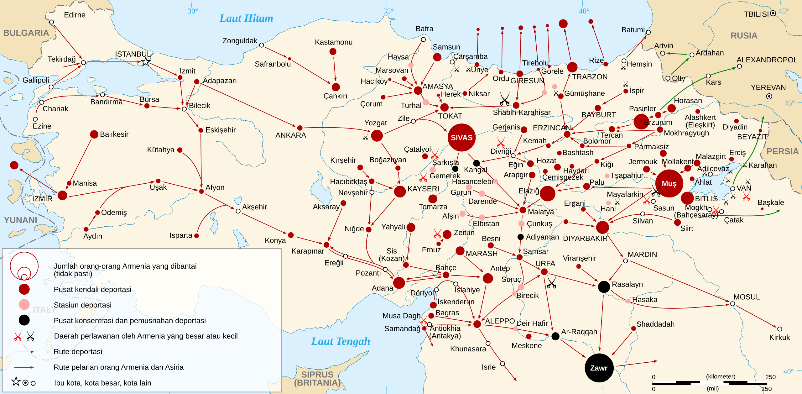
Bahasa Indonesia: Peta Genosida Armenia tahun 1915
|
| Date | |
| Source |
Other data :
|
| Author | Sémhur |
| Other versions |
[]
|


Licensing[edit]
I, the copyright holder of this work, hereby publish it under the following licenses:

|
Permission is granted to copy, distribute and/or modify this document under the terms of the GNU Free Documentation License, Version 1.2 or any later version published by the Free Software Foundation; with no Invariant Sections, no Front-Cover Texts, and no Back-Cover Texts. A copy of the license is included in the section entitled GNU Free Documentation License. |
This file is licensed under the Creative Commons Attribution-Share Alike 3.0 Unported, 2.5 Generic, 2.0 Generic and 1.0 Generic license.
- You are free:
- to share – to copy, distribute and transmit the work
- to remix – to adapt the work
- Under the following conditions:
- attribution – You must give appropriate credit, provide a link to the license, and indicate if changes were made. You may do so in any reasonable manner, but not in any way that suggests the licensor endorses you or your use.
- share alike – If you remix, transform, or build upon the material, you must distribute your contributions under the same or compatible license as the original.
You may select the license of your choice.
File history
Click on a date/time to view the file as it appeared at that time.
| Date/Time | Thumbnail | Dimensions | User | Comment | |
|---|---|---|---|---|---|
| current | 14:58, 29 April 2021 | | 2,574 × 1,264 (463 KB) | Ivan Humphrey (talk | contribs) | Uploaded a work by Sémhur from |Source= * Topographic background : [http://www2.jpl.nasa.gov/srtm NASA Shuttle Radar Topography Mission] (SWBD) (public domain) * Image:Armeniangenocidemap.gif by Vahagn Avedian, from the website http://www.armenica.org, uploaded on Commons by {{U|Electionworld}} under license GFDL. (Note: Armenica map is a clone of Map 224 (''The Armenian Genocide, 1915 (after J. Naslian and B.H. Harutyunyan)'' in {{cite book|last=Hewsen|first=Robert H.|ye... |
You cannot overwrite this file.
File usage on Commons
The following 18 pages use this file:
- User:Magog the Ogre/Maps of conflicts/2021 April
- User:Magog the Ogre/Multilingual legend/2021 April 21-30
- File:Armenian Genocide Map-ar.svg
- File:Armenian Genocide Map-el.jpg
- File:Armenian Genocide Map-en.svg
- File:Armenian Genocide Map-es.svg
- File:Armenian Genocide Map-fr.svg
- File:Armenian Genocide Map-frp.svg
- File:Armenian Genocide Map-hu.svg
- File:Armenian Genocide Map-hy.svg
- File:Armenian Genocide Map-id.svg
- File:Armenian Genocide Map-mk.svg
- File:Armenian Genocide Map-ro.svg
- File:Armenian Genocide Map-ru.svg
- File:Armenian Genocide Map-sr-ec.svg
- File:Armenian Genocide Map-tr.svg
- File:Armeniangenocidemap.gif
- Template:Other versions/Armenian Genocide Map
File usage on other wikis
The following other wikis use this file:
- Usage on id.wikipedia.org