File:Arquipélago de Mariauá.jpg
Jump to navigation
Jump to search

Size of this preview: 800 × 450 pixels. Other resolutions: 320 × 180 pixels | 640 × 360 pixels | 1,024 × 576 pixels | 1,280 × 720 pixels | 2,712 × 1,526 pixels.
Original file (2,712 × 1,526 pixels, file size: 2.32 MB, MIME type: image/jpeg)
Captions
Captions
Add a one-line explanation of what this file represents
Summary
[edit]
| Description |
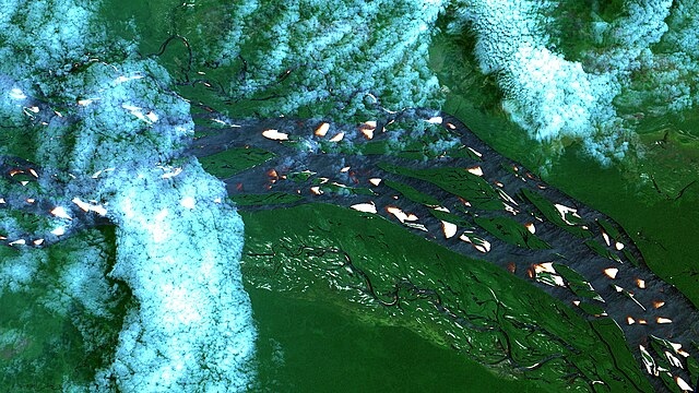
English: Parte do Arquipélago de Mariauá no Rio Negro, em Barcelos, Amazonas. No Rio Negro, que cruza a imagem de NO a SE: Em branco praias, em alaranjado bancos de areia, água do rio em preto e em cinza quando coberta por fina névoa. Embaixo à esquerda da imagem está o Rio Ararirá, correndo na mesma direção. Floresta de várzea em verde, campinarana em verde claro e tons amarronzados, areais em branco, floresta de terra firme em verde escuro / Negro River´s Mariauá Archipelago, at Barcelos, Brazilian Amazon State. At Negro River, crossing image from NW to SE: Beaches and sand banks in white, shallows in orange, river water in black and in grey when mist covered. At image bottom left is, running in same direction, Ararirá River. Lowland forest in green, campinarana in light green and brownish green, sandy areas in white, dryland Amazon forest in dark green.
Imagem / Image CBERS4 MUX Praias e bancos de areia / Beaches and sand banks, Rio Negro, Barcelos/AM. Coordenadas do centro da imagem / Image center: 0°23'02.2"S 63°37'26.0"W Data / Date: 09-02-2020 / 2020-09-02 RGB 765 (cor verdadeira / true color) Cena / Scene: 178 / 100 Autor / Author: Oton Barros (DSR/OBT/INPE) Imagem em HD / HD Image Visite-nos em www.dsr.inpe.br |
| Date | |
| Source | https://www.flickr.com/photos/153282474@N02/49521182466/ |
| Author | Coordenação-Geral de Observação da Terra/INPE |
Licensing
[edit]
This file is licensed under the Creative Commons Attribution-Share Alike 2.0 Generic license.
- You are free:
- to share – to copy, distribute and transmit the work
- to remix – to adapt the work
- Under the following conditions:
- attribution – You must give appropriate credit, provide a link to the license, and indicate if changes were made. You may do so in any reasonable manner, but not in any way that suggests the licensor endorses you or your use.
- share alike – If you remix, transform, or build upon the material, you must distribute your contributions under the same or compatible license as the original.
| This image was originally posted to Flickr by Coordenação-Geral de Observação da Terra/INPE at https://flickr.com/photos/153282474@N02/49521182466. It was reviewed on 9 April 2020 by FlickreviewR 2 and was confirmed to be licensed under the terms of the cc-by-sa-2.0. |
File history
Click on a date/time to view the file as it appeared at that time.
| Date/Time | Thumbnail | Dimensions | User | Comment | |
|---|---|---|---|---|---|
| current | 10:12, 9 April 2020 | | 2,712 × 1,526 (2.32 MB) | Jo-Jo Eumerus (talk | contribs) | Uploaded a work by Coordenação-Geral de Observação da Terra/INPE from https://www.flickr.com/photos/153282474@N02/49521182466/ with UploadWizard |
You cannot overwrite this file.
File usage on Commons
The following 2 pages use this file:
.jpg&redirect=no)
File usage on other wikis
The following other wikis use this file: