File:Asia Europe transcontinental.png
Jump to navigation
Jump to search

Size of this preview: 763 × 599 pixels. Other resolutions: 306 × 240 pixels | 611 × 480 pixels | 978 × 768 pixels | 1,268 × 996 pixels.
Original file (1,268 × 996 pixels, file size: 46 KB, MIME type: image/png)
Captions
Captions
Add a one-line explanation of what this file represents
| Description |
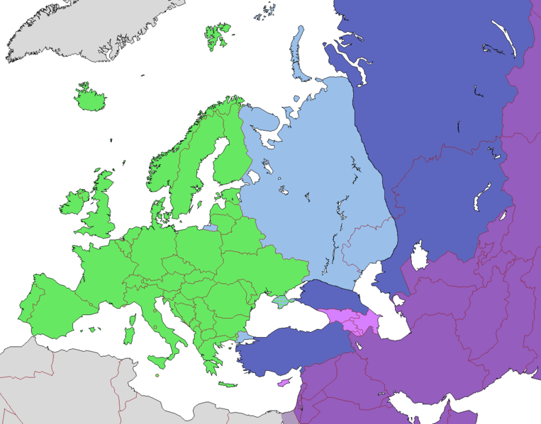
English: Map of Europe, indicating continental boundary (by Britannica and Great Soviet Encyclopedia) and transcontinental states.
States geographically in Europe (excepting overseas possessions)
Transcontinental states, European territory
Transcontinental states, Asian territory
Asian countries, sometimes referred to as Europe according to political, economic, and historical and cultural criteria (Azerbaijan, Armenia, Georgia, Cyprus)
Geographically Asian states (island states of Cyprus and Bahrain usually grouped with Asia geographically)
Asian part of Egypt Русский: Карта Европы с указанием границ частей света (по БСЭ и Британнике) и трансконтинентальных государств.
Государства, расположенные в Европе (за исключением заморских владений)
Трансконтинентальные государства, европейская территория
Трансконтинентальные государства, азиатская территория
Государства Азии, иногда относимые к Европе по политическим, экономическим, и историко-культурным критериям
Государства, расположенные в Азии
Азиатская часть Египта |
| Date | |
| Source | |
| Author |
.png)
Licensing[edit]
This file is licensed under the Creative Commons Attribution-Share Alike 3.0 Unported license.
- You are free:
- to share – to copy, distribute and transmit the work
- to remix – to adapt the work
- Under the following conditions:
- attribution – You must give appropriate credit, provide a link to the license, and indicate if changes were made. You may do so in any reasonable manner, but not in any way that suggests the licensor endorses you or your use.
- share alike – If you remix, transform, or build upon the material, you must distribute your contributions under the same or compatible license as the original.
| Annotations | This image is annotated: View the annotations at Commons |
File history
Click on a date/time to view the file as it appeared at that time.
| Date/Time | Thumbnail | Dimensions | User | Comment | |
|---|---|---|---|---|---|
| current | 10:23, 14 November 2022 | | 1,268 × 996 (46 KB) | Рагин1987 (talk | contribs) | Highlighted with a light purple hue the countries of Asia, sometimes attributed to Europe according to political, economic, and historical and cultural criteria (Transcaucasia, Cyprus). |
| 12:02, 29 August 2022 |  | 1,268 × 996 (46 KB) | Рагин1987 (talk | contribs) | Small correction | |
| 07:03, 18 February 2020 |  | 1,268 × 996 (56 KB) | Insider (talk | contribs) | fix: mixed color. not dark blue | |
| 06:55, 18 February 2020 |  | 1,268 × 996 (60 KB) | Insider (talk | contribs) | Reverted to version as of 07:01, 13 October 2014 (UTC) Crimea that is Europe | |
| 09:04, 10 February 2020 |  | 1,268 × 996 (84 KB) | Compu wiki (talk | contribs) | Крым — это Россия. Crimea is Russia. | |
| 07:01, 13 October 2014 |  | 1,268 × 996 (60 KB) | Insider (talk | contribs) | Reverted to version as of 10:10, 1 July 2014 Crimea that is Europe | |
| 12:31, 11 October 2014 |  | 1,268 × 996 (84 KB) | Michael1238 (talk | contribs) | Crimea | |
| 10:10, 1 July 2014 |  | 1,268 × 996 (60 KB) | Insider (talk | contribs) | {{Information |Description={{en|1= Map of Europe, indicating continental boundary and transcontinental states. {{legend|#67e836|States geographically in Europe (excepting overseas possessions; island states UK, Ireland, Iceland and Malta usually group... |
You cannot overwrite this file.
File usage on Commons
The following page uses this file:
File usage on other wikis
The following other wikis use this file:
- Usage on hy.wikipedia.org
- Usage on kk.wikipedia.org
- Usage on ru.wikipedia.org