File:Asien 1844.jpg
Jump to navigation
Jump to search
Size of this preview: 733 × 600 pixels. Other resolutions: 293 × 240 pixels | 587 × 480 pixels | 938 × 768 pixels | 1,251 × 1,024 pixels | 2,502 × 2,048 pixels | 5,475 × 4,481 pixels.
Original file (5,475 × 4,481 pixels, file size: 7.31 MB, MIME type: image/jpeg)
Captions
Captions
Add a one-line explanation of what this file represents
Summary[edit]
| Description |
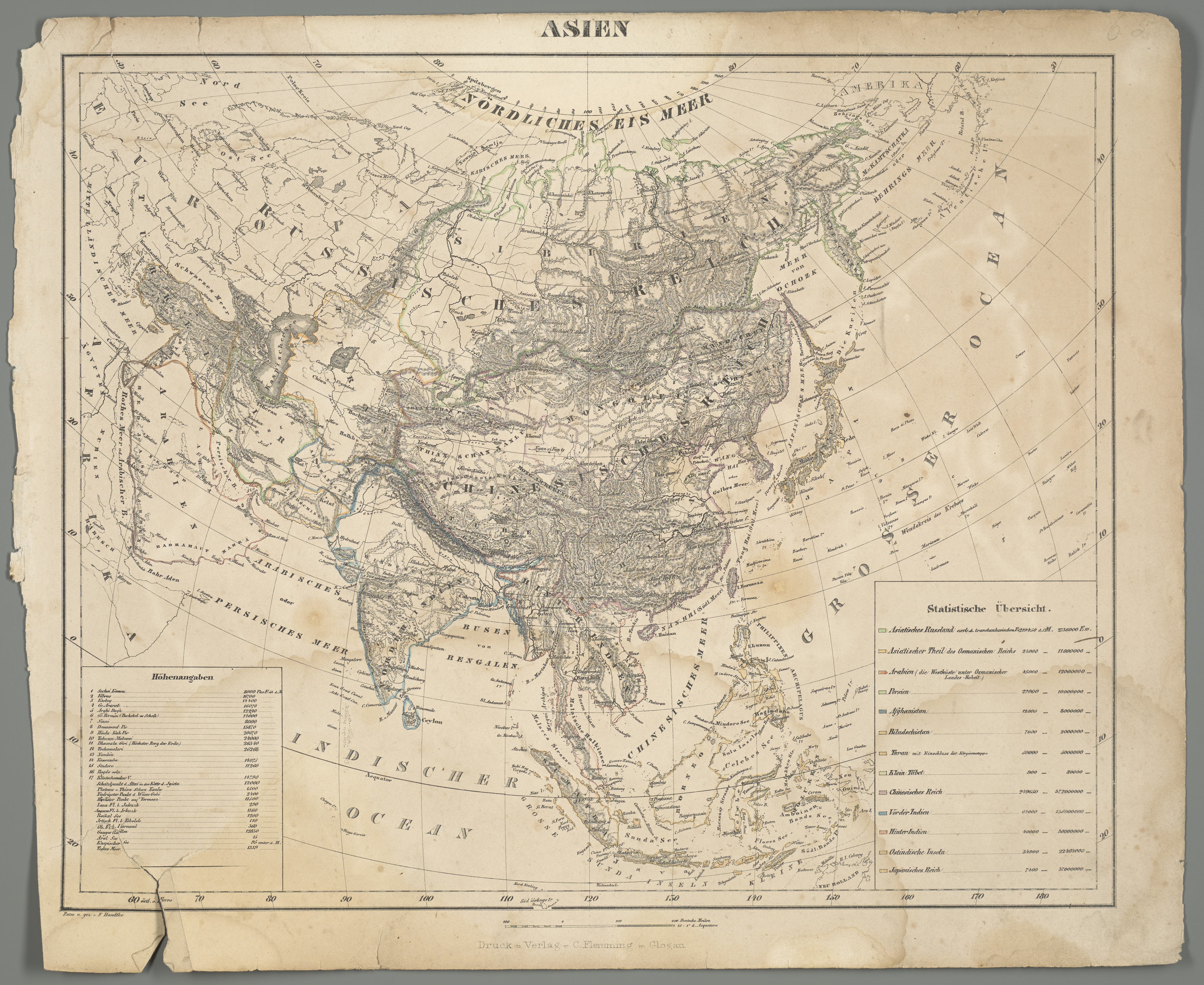
Deutsch: 1 Kt. : Grenzen kolor. (40 x 33 cm) ; Koordinaten E 5°09'00"-W 151°52'00"/N 81°49'00"-S 13°34'00" ; Aus: Vollständiger Hand-Atlas der neueren Erdbeschreibung ueber alle Theile der Erde ; 65. - Maßstab in graph. Form (Deutsche Meilen). - Titel oberhalb des Kt.-Feldes. - Maßstab unterhalb des Kt.-Feldes. - Nullmeridian: Ferro, Paris Kopft. - Mit statist. Angaben unten rechts. - Mit Höhenangaben unten links. - Relief: Schraffen |
| Date | |
| Source | Leibniz-Institut für Länderkunde e.V., Leipzig |
| Author | Flemming, Carl (Herausgeber/-in) ; Handtke, Friedrich |
Altkarte
Licensing[edit]
| This file is made available under the Creative Commons CC0 1.0 Universal Public Domain Dedication. | |
| The person who associated a work with this deed has dedicated the work to the public domain by waiving all of their rights to the work worldwide under copyright law, including all related and neighboring rights, to the extent allowed by law. You can copy, modify, distribute and perform the work, even for commercial purposes, all without asking permission.
|
File history
Click on a date/time to view the file as it appeared at that time.
| Date/Time | Thumbnail | Dimensions | User | Comment | |
|---|---|---|---|---|---|
| current | 13:21, 11 March 2019 | | 5,475 × 4,481 (7.31 MB) | Higgenhorscht (talk | contribs) | User created page with UploadWizard |
You cannot overwrite this file.
File usage on Commons
There are no pages that use this file.
File usage on other wikis
The following other wikis use this file:
- Usage on fr.wikipedia.org