File:Assam districts map.svg
Jump to navigation
Jump to search

Size of this PNG preview of this SVG file: 800 × 553 pixels. Other resolutions: 320 × 221 pixels | 640 × 443 pixels | 1,024 × 708 pixels | 1,280 × 885 pixels | 2,560 × 1,770 pixels | 1,326 × 917 pixels.
Original file (SVG file, nominally 1,326 × 917 pixels, file size: 522 KB)
Captions
Captions
Map of Assam
Summary[edit]
| Description |
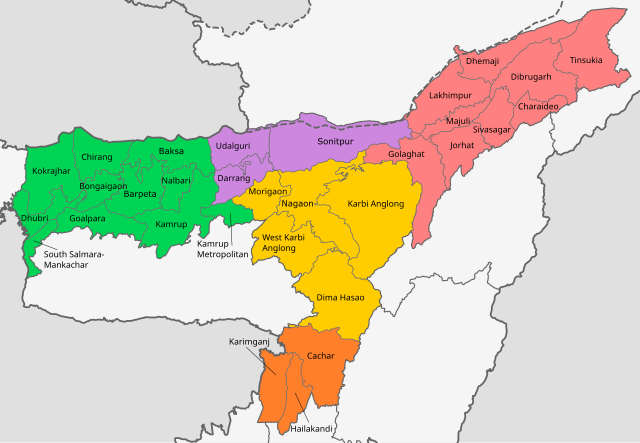
English: Map of districts of Assam, coloured by division. |
| Date |
|
| Source | Derivative of File:India Assam location map.svg |
| Author | Own work based on User:Milenioscuro |
Licensing[edit]
This file is licensed under the Creative Commons Attribution-Share Alike 4.0 International license.
- You are free:
- to share – to copy, distribute and transmit the work
- to remix – to adapt the work
- Under the following conditions:
- attribution – You must give appropriate credit, provide a link to the license, and indicate if changes were made. You may do so in any reasonable manner, but not in any way that suggests the licensor endorses you or your use.
- share alike – If you remix, transform, or build upon the material, you must distribute your contributions under the same or compatible license as the original.
File history
Click on a date/time to view the file as it appeared at that time.
| Date/Time | Thumbnail | Dimensions | User | Comment | |
|---|---|---|---|---|---|
| current | 11:54, 14 July 2023 | | 1,326 × 917 (522 KB) | Turtle-bienhoa (talk | contribs) | Merge 4 districts |
| 16:04, 20 July 2022 |  | 1,326 × 917 (510 KB) | C1MM (talk | contribs) | Uploaded a work by Own work based on User:Milenioscuro from Derivative of File:India Assam location map.svg with UploadWizard |
You cannot overwrite this file.
File usage on Commons
There are no pages that use this file.
File usage on other wikis
The following other wikis use this file:
- Usage on en.wikipedia.org
- Usage on ml.wikipedia.org
- Usage on ne.wikipedia.org
- Usage on simple.wikipedia.org
- Usage on ta.wikipedia.org
- Usage on te.wikipedia.org
- Usage on ur.wikipedia.org
- Usage on zh.wikipedia.org