File:Atlas Van der Hagen-KW1049B10 018-ZEELANDIA INSULA Danicarum Maxima.jpeg
Jump to navigation
Jump to search

Size of this preview: 727 × 599 pixels. Other resolutions: 291 × 240 pixels | 582 × 480 pixels | 932 × 768 pixels | 1,242 × 1,024 pixels | 2,484 × 2,048 pixels | 5,500 × 4,535 pixels.
Original file (5,500 × 4,535 pixels, file size: 3.24 MB, MIME type: image/jpeg)
Captions
Captions
Add a one-line explanation of what this file represents
Summary[edit]
| Dirk Jansz van Santen: Atlas van Dirk van der Hagen (volledig, collectie KB)
|
|||||||||||||||||||||||||||||
|---|---|---|---|---|---|---|---|---|---|---|---|---|---|---|---|---|---|---|---|---|---|---|---|---|---|---|---|---|---|
| Artist |
|
 | |||||||||||||||||||||||||||
| Author |
Publisher:
|
||||||||||||||||||||||||||||
| Title |
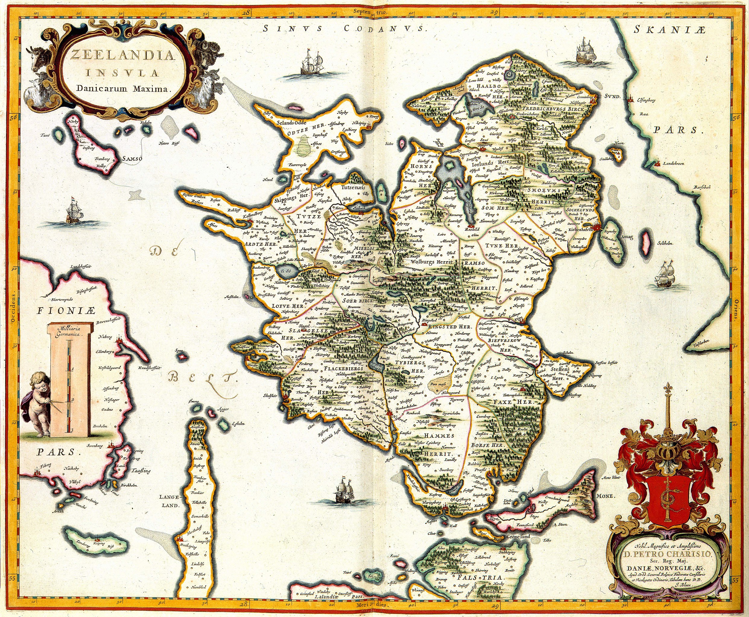
ZEELANDIA INSULA Danicarum Maxima |
||||||||||||||||||||||||||||
| Object type | map | ||||||||||||||||||||||||||||
| Description |
Nederlands: De kaart van het Deense eiland Sjaelland was het resultaat van de topografsche opname van het Deense rijk die vanaf 1630 in opdracht van Koning Christian IV onder toezicht van Johann Lauremberg (1590-1658) en Johannes Mejer (1606-1674) werd uitgevoerd. De kaart werd in 1662 gepubliceerd in de Atlas Maior van Joan Blaeu (1598-1673). Blaeu droeg de kaart op Petrus Charisius (overleden 1683). Charisius was van 1651 tot 1669 de oficieele vertegenwoordiger van Denemarken en Noorwegen in Den Haag.; Rechtsonder een opdracht van Joan Blaeu aan Petrus Charisius.
English: The map of the Danish island Sjaelland was the result of a survey of the Danish kingdom which was carried out under orders from king ChristianIV in 1630 carried out under supervision of Johann Lauremberg (1590-1658) and Johannes Mejer (1606-1674). The map was published in 1662 in the Atlas Maior by Joan Blaeu (1598-1673). Blaeu dedicated the map to Petrus Charisius (deceased 1683). Charisius was official representative between 1651 to 1669 of Denmark and Norway in The Hague. |
||||||||||||||||||||||||||||
| Language |
Dutch |
||||||||||||||||||||||||||||
| Date | 1662 | ||||||||||||||||||||||||||||
| Publication date |
circa |
||||||||||||||||||||||||||||
| Medium |
Nederlands: kopergravure
English: copper engraving print |
||||||||||||||||||||||||||||
| Dimensions | 43 x 53 cm | ||||||||||||||||||||||||||||
| Collection |
|
||||||||||||||||||||||||||||
| Accession number |
Description of the Atlas Van der Hagen in the catalogue of the KB: http://opc4.kb.nl/DB=1/TTL=1/LNG=EN/PPN?PPN=353012750 |
||||||||||||||||||||||||||||
| Place of creation | Amsterdam | ||||||||||||||||||||||||||||
| Notes | KW1049B10_018 - Volume 1 | ||||||||||||||||||||||||||||
| Related persons | Joan Blaeu - Johann Lauremberg - Charisius, Petrus | ||||||||||||||||||||||||||||
| Depicted locations | Sjaelland - Denmark | ||||||||||||||||||||||||||||
| References | |||||||||||||||||||||||||||||
| Source/Photographer |
Source page at the Geheugen van Nederland / Memory of the Netherlands website.
|
||||||||||||||||||||||||||||
.jpg)

Licensing[edit]
|
This is a faithful photographic reproduction of a two-dimensional, public domain work of art. The work of art itself is in the public domain for the following reason:
The official position taken by the Wikimedia Foundation is that "faithful reproductions of two-dimensional public domain works of art are public domain".
This photographic reproduction is therefore also considered to be in the public domain in the United States. In other jurisdictions, re-use of this content may be restricted; see Reuse of PD-Art photographs for details. | ||||
File history
Click on a date/time to view the file as it appeared at that time.
| Date/Time | Thumbnail | Dimensions | User | Comment | |
|---|---|---|---|---|---|
| current | 07:57, 19 July 2015 | | 5,500 × 4,535 (3.24 MB) | OlafJanssen (talk | contribs) | GWToolset: Creating mediafile for OlafJanssen. |
You cannot overwrite this file.
File usage on Commons
The following 3 pages use this file: