File:Augusta Treverorum Stadtplan.png
Jump to navigation
Jump to search
Size of this preview: 685 × 599 pixels. Other resolutions: 274 × 240 pixels | 549 × 480 pixels | 878 × 768 pixels | 1,170 × 1,024 pixels | 1,800 × 1,575 pixels.
Original file (1,800 × 1,575 pixels, file size: 2.38 MB, MIME type: image/png)
Captions
Captions
Add a one-line explanation of what this file represents
Summary[edit]
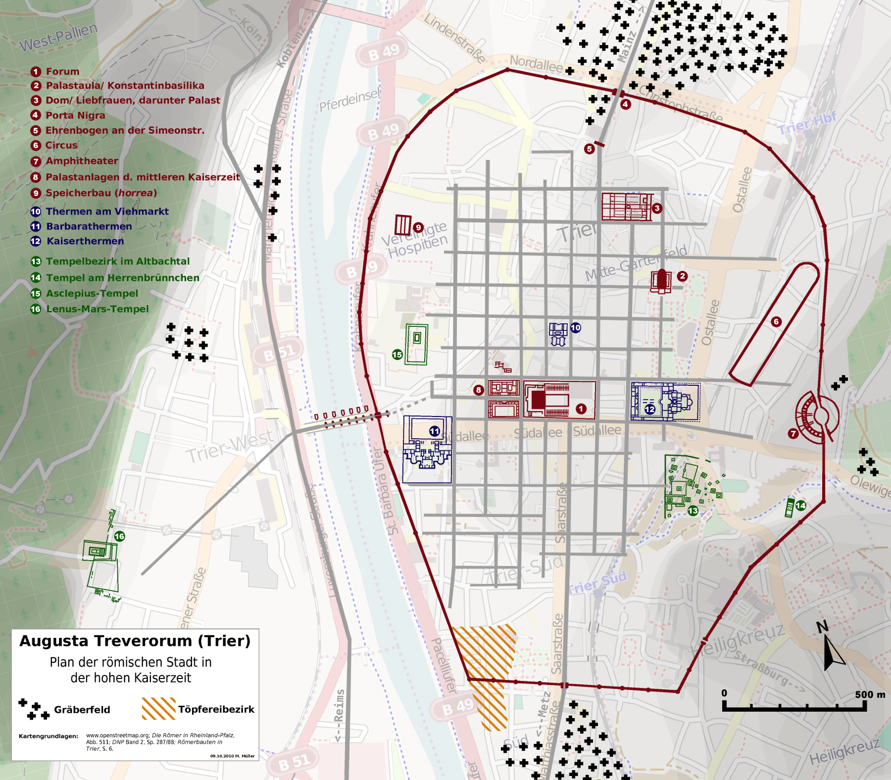
| Description |
Deutsch: Stadtplan der römischen Stadt Trier (de:Augusta Treverorum). English: Map of Trier in roman times (Augusta Treverorum). |
| Date | |
| Source | openstreetmap.org [1] + own work |
| Author | Contributors of the relevant openstreetmap.org data + Haselburg-müller |
Licensing[edit]
I, the copyright holder of this work, hereby publish it under the following license:
This file is licensed under the Creative Commons Attribution-Share Alike 2.0 Generic license.
- You are free:
- to share – to copy, distribute and transmit the work
- to remix – to adapt the work
- Under the following conditions:
- attribution – You must give appropriate credit, provide a link to the license, and indicate if changes were made. You may do so in any reasonable manner, but not in any way that suggests the licensor endorses you or your use.
- share alike – If you remix, transform, or build upon the material, you must distribute your contributions under the same or compatible license as the original.
| Annotations | This image is annotated: View the annotations at Commons |


File history
Click on a date/time to view the file as it appeared at that time.
| Date/Time | Thumbnail | Dimensions | User | Comment | |
|---|---|---|---|---|---|
| current | 01:48, 9 October 2010 | | 1,800 × 1,575 (2.38 MB) | Lumpeseggl (talk | contribs) | {{Information |Description={{de|1=Stadtplan der römischen Stadt Trier (de:Augusta Treverorum).}} |Source=openstreetmap.org [http://www.openstreetmap.org/?lat=49.7514&lon=6.6509&zoom=14&layers=M] + own work |Author=Contributors of the relevant openst |
You cannot overwrite this file.
File usage on Commons
The following 2 pages use this file:
File usage on other wikis
The following other wikis use this file:
- Usage on ca.wikipedia.org
- Usage on de.wikipedia.org
- Städtebau
- Amphitheater (Trier)
- Treverer
- Konstantinbasilika
- Porta Nigra
- Römerbrücke (Trier)
- Augusta Treverorum
- Trierer Dom
- Kaiserthermen (Trier)
- Portal:Römisches Reich/Exzellente Artikel
- Stadtbaugeschichte
- Thermen am Viehmarkt
- Reichsabtei St. Maximin
- Barbarathermen
- Igeler Säule
- Neumagener Weinschiff
- Kaiservilla von Konz
- Cardo
- Langmauer
- Porta Alba
- Villa Otrang
- Römischer Tempelbezirk Tawern
- Benutzer:Lumpeseggl/Bilder
- Villa Rustica (Mehring)
- Villa Urbana in Longuich
- Villa rustica (Bollendorf)
- Römische Baudenkmäler, Dom und Liebfrauenkirche in Trier
- Grutenhäuschen
- Römische Ruwerwasserleitung
- Palatiolum
- Tempelbezirk im Altbachtal
- Tempelbezirk Irminenwingert
- Tempel am Herrenbrünnchen
- Franzensknüppchen
- Trierer Spruchbecher
- Vorlage:Navigationsleiste Römisches Trier
- Asclepius-Tempel Trier
- Römischer Qanat (Mehring)
- Villa rustica (Wasserliesch)
- Römischer Qanat (Pölich)
- Porta Media
- Porta Inclyta
- Römersprudel
- Trierer Goldmünzenschatz
- Noviomagus Treverorum
- Silberschatz von Trier
- Villa rustica Newel
- Grabkammer am Reichertsberg
- Römische Villen, Leiwen
View more global usage of this file.