File:Aurora Kp Map Africa and Oceania.png
Jump to navigation
Jump to search
Size of this preview: 800 × 400 pixels. Other resolutions: 320 × 160 pixels | 850 × 425 pixels.
Original file (850 × 425 pixels, file size: 13 KB, MIME type: image/png)
Captions
Captions
Add a one-line explanation of what this file represents
Summary[edit]
| Description |
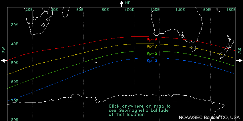
English: This map shows the midnight equatorward boundary of the aurora phenomena at different levels of geomagnetic activity. A Kp=3 represents very low geomagnetic activity, while a Kp=9 represents a very high level. |
| Date | |
| Source | http://www.swpc.noaa.gov/Aurora/index.html#kpmaps |
| Author | NOAA National Weather Service Space Weather Prediction Center |
Licensing[edit]
This image is in the public domain because it contains materials that originally came from the U.S. National Oceanic and Atmospheric Administration, taken or made as part of an employee's official duties.
|
Original upload log[edit]
| Date/Time | Dimensions | User | Comment |
|---|---|---|---|
| 29 October 2011, 00:11:40 | 850 × 425 (11752 bytes) | Darkest tree (talk · contribs) |
File history
Click on a date/time to view the file as it appeared at that time.
| Date/Time | Thumbnail | Dimensions | User | Comment | |
|---|---|---|---|---|---|
| current | 18:03, 18 August 2014 | | 850 × 425 (13 KB) | GifTagger (talk | contribs) | Bot: Converting file to superior PNG file. (Source: Aurora_Kp_Map_Africa_and_Oceania.gif). This GIF was problematic due to non-greyscale color table. |
You cannot overwrite this file.
File usage on Commons
The following page uses this file:
- File:Aurora Kp Map Africa and Oceania.gif (file redirect)