File:Australia and Oceania-administrative map PL.png
Jump to navigation
Jump to search
Size of this preview: 800 × 579 pixels. Other resolutions: 320 × 231 pixels | 640 × 463 pixels | 940 × 680 pixels.
Original file (940 × 680 pixels, file size: 237 KB, MIME type: image/png)
Captions
Captions
Add a one-line explanation of what this file represents
| Description |
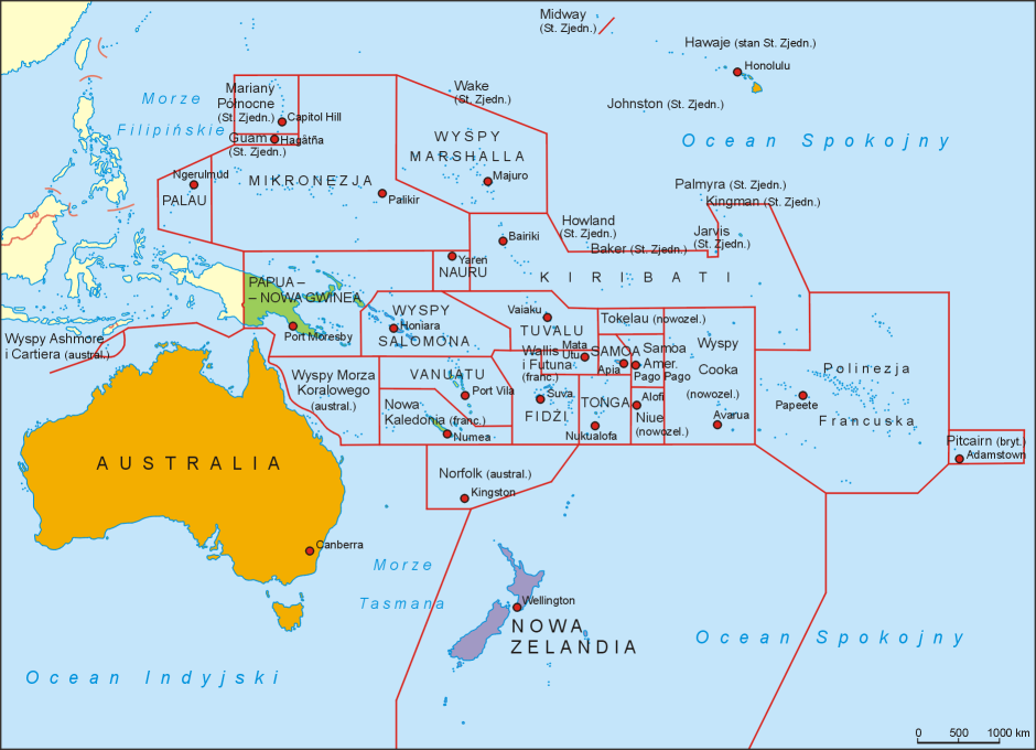
Polski: Mapa polityczna Oceanii. Autor: Aotearoa |
| Date | 22 April 2006 (original upload date) |
| Source | Transferred from pl.wikipedia to Commons by Pjahr using CommonsHelper. |
| Author | Aotearoa at Polish Wikipedia |
Licensing
[edit]
Aotearoa at Polish Wikipedia, the copyright holder of this work, hereby publishes it under the following license:

|
Permission is granted to copy, distribute and/or modify this document under the terms of the GNU Free Documentation License, Version 1.2 or any later version published by the Free Software Foundation; with no Invariant Sections, no Front-Cover Texts, and no Back-Cover Texts. A copy of the license is included in the section entitled GNU Free Documentation License. |
| This file is licensed under the Creative Commons Attribution-Share Alike 3.0 Unported license. | ||
| Attribution: Aotearoa at Polish Wikipedia | ||
| ||
| This licensing tag was added to this file as part of the GFDL licensing update. |
Original upload log
[edit]
The original description page was here. All following user names refer to pl.wikipedia.
- 2006-04-22 07:16 Aotearoa 1879×1359× (401621 bytes) Mapa polityczna Oceanii. Autor: [[Wikipedysta:Aotearoa|Aotearoa]]
File history
Click on a date/time to view the file as it appeared at that time.
| Date/Time | Thumbnail | Dimensions | User | Comment | |
|---|---|---|---|---|---|
| current | 21:11, 27 February 2013 | | 940 × 680 (237 KB) | Szczureq (talk | contribs) | Usunięto rafy Maria Theresa i Ernest Legouve, których istnienie nie zostało potwierdzone |
| 12:23, 10 December 2009 |  | 940 × 680 (227 KB) | Aotearoa (talk | contribs) | Zmiana stolicy Palau z Koror na Ngerulmud | |
| 15:34, 27 November 2009 |  | 1,879 × 1,359 (392 KB) | File Upload Bot (Magnus Manske) (talk | contribs) | {{BotMoveToCommons|pl.wikipedia|year={{subst:CURRENTYEAR}}|month={{subst:CURRENTMONTHNAME}}|day={{subst:CURRENTDAY}}}} {{Information |Description={{pl|Mapa polityczna Oceanii. Autor: Aotearoa}} |Source=Transferred from [http: |
You cannot overwrite this file.
File usage on Commons
There are no pages that use this file.
File usage on other wikis
The following other wikis use this file:
- Usage on en.wikipedia.org
- Usage on pl.wikipedia.org
- Melanezja
- Oceania
- Polinezja
- Sitiveni Rabuka
- Australia i Oceania
- David Adeang
- Mapa polityczna
- Tupou VI
- Szablon:Szefowie państw i rządów Australii i Oceanii
- Wikipedysta:Aotearoa/mapy
- Anthony Albanese
- Lista państw Australii i Oceanii
- Iolu Abil
- Wesley Simina
- Wikipedysta:Piotr Rogalski/Oceania
- Joe Natuman
- David Hurley
- Wikipedysta:KamilosR/brudnopis 28/Szablon:Szefowie państw i rządów
- Scott Morrison
- Hilda Heine
- Charlot Salwai
- Taneti Maamau
- Bob Dadae
- Tuimalealiʻifano Vaʻaletoa Sualauvi II
- Tallis Obed Moses
- James Marape
- David Vunagi
- Surangel Whipps Jr.
- Naomi Mataʻafa
- Wiliame Katonivere
- Tofiga Vaevalu Falani
- Nikenike Vurobaravu
- Cindy Kiro
- Siaosi Sovaleni
- Christopher Luxon
- Usage on pl.wikivoyage.org