File:BMO Field, Toronto, Ontario (29358641183).jpg

Original file (4,000 × 1,334 pixels, file size: 3.11 MB, MIME type: image/jpeg)
Captions
Captions
Summary[edit]
.jpg&action=edit§ion=1)
| Description |
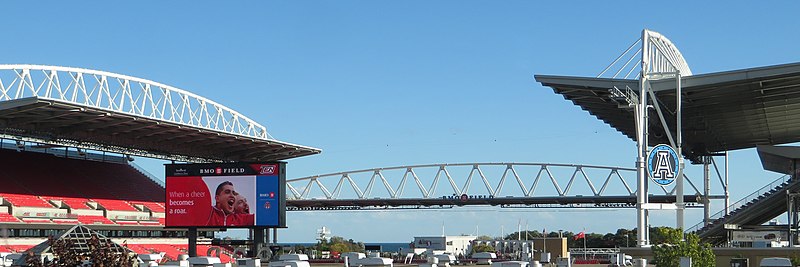
BMO Field is an outdoor stadium located at Exhibition Place in Toronto, Ontario, Canada, which is home to Toronto FC of Major League Soccer and the Toronto Argonauts of the Canadian Football League. Constructed on the site of the former Exhibition Stadium and first opened in 2007, it is owned by the City of Toronto government, and managed by Maple Leaf Sports & Entertainment. The stadium's naming rights are held by the Bank of Montreal, which is commonly branded as "BMO". BMO Field was originally constructed as a soccer-specific stadium to serve as the home field of the expansion Toronto FC, and hosted matches during the 2007 FIFA U-20 World Cup and 2014 FIFA U-20 Women's World Cup. In 2010, when it was still a neutral-site game, BMO Field hosted the MLS Cup. It has since hosted the 2016 and 2017 finals featuring Toronto FC, under the current practice of giving home field advantage to the side with the better regular season record. The venue has also hosted rugby union, including matches of Canada's national team, and rugby sevens during the 2015 Pan-American Games. From 2014 to 2016, the stadium underwent a series of major renovations, which added an upper deck to the east grandstand, a roof over the seating areas and lengthened the field to make it suitable for hosting Canadian football. The latter allowed for the Toronto Argonauts to move to BMO Field beginning with the 2016 CFL season, which also saw the 104th Grey Cup played at the stadium. <a href="https://en.wikipedia.org/wiki/BMO_Field" rel="noreferrer nofollow">en.wikipedia.org/wiki/BMO_Field</a> <a href="https://en.wikipedia.org/wiki/Wikipedia:Text_of_Creative_Commons_Attribution-ShareAlike_3.0_Unported_License" rel="noreferrer nofollow">en.wikipedia.org/wiki/Wikipedia:Text_of_Creative_Commons_...</a> |
| Date | |
| Source | BMO Field, Toronto, Ontario |
| Author | Ken Lund from Reno, Nevada, USA |
| Camera location | | View this and other nearby images on: OpenStreetMap |
|---|
.jpg¶ms=043.635030_N_-079.420667_E_globe:Earth_type:camera_source:Flickr_&language=en)
Licensing[edit]
.jpg&action=edit§ion=2)
- You are free:
- to share – to copy, distribute and transmit the work
- to remix – to adapt the work
- Under the following conditions:
- attribution – You must give appropriate credit, provide a link to the license, and indicate if changes were made. You may do so in any reasonable manner, but not in any way that suggests the licensor endorses you or your use.
- share alike – If you remix, transform, or build upon the material, you must distribute your contributions under the same or compatible license as the original.
| This image was originally posted to Flickr by Ken Lund at https://flickr.com/photos/75683070@N00/29358641183. It was reviewed on 10 March 2022 by FlickreviewR 2 and was confirmed to be licensed under the terms of the cc-by-sa-2.0. |
File history
Click on a date/time to view the file as it appeared at that time.
| Date/Time | Thumbnail | Dimensions | User | Comment | |
|---|---|---|---|---|---|
| current | 19:02, 10 March 2022 | 4,000 × 1,334 (3.11 MB) | Mindmatrix (talk | contribs) | Transferred from Flickr via #flickr2commons |
You cannot overwrite this file.
File usage on Commons
There are no pages that use this file.
.jpg&oldid=810578755)