File:Barnes FC Map.png
Jump to navigation
Jump to search

Size of this preview: 800 × 295 pixels. Other resolutions: 320 × 118 pixels | 640 × 236 pixels | 1,024 × 378 pixels | 1,280 × 472 pixels | 3,676 × 1,356 pixels.
Original file (3,676 × 1,356 pixels, file size: 5.93 MB, MIME type: image/png)
Captions
Captions
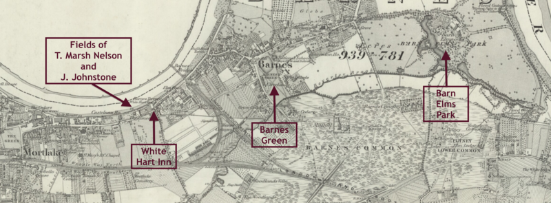
Map of locations significant to the early development of Barnes FC.
Summary
[edit]
| Description |
English: Map of Mortlake and Barnes, Surrey from the Ordnance Survey Six Inch Series, (surveyed 1866 and published 1874), annotated with locations significant to the early development of Barnes FC. |
| Date | |
| Source | Annotations added by uploader |
| Author | Ordnance Survey |
Licensing
[edit]
This work is in the public domain in the United States because it was published (or registered with the U.S. Copyright Office) before January 1, 1929.
Public domain works must be out of copyright in both the United States and in the source country of the work in order to be hosted on the Commons. If the work is not a U.S. work, the file must have an additional copyright tag indicating the copyright status in the source country.
Note: This tag should not be used for sound recordings. |
File history
Click on a date/time to view the file as it appeared at that time.
| Date/Time | Thumbnail | Dimensions | User | Comment | |
|---|---|---|---|---|---|
| current | 23:11, 18 October 2019 | 3,676 × 1,356 (5.93 MB) | Grover cleveland (talk | contribs) | User created page with UploadWizard |
You cannot overwrite this file.
File usage on Commons
There are no pages that use this file.
File usage on other wikis
The following other wikis use this file:
- Usage on en.wikipedia.org