File:Bayrgmain01.jpg
Jump to navigation
Jump to search

Size of this preview: 800 × 572 pixels. Other resolutions: 320 × 229 pixels | 640 × 458 pixels | 1,024 × 732 pixels | 1,280 × 916 pixels | 1,707 × 1,221 pixels.
Original file (1,707 × 1,221 pixels, file size: 2.05 MB, MIME type: image/jpeg)
Captions
Captions
Add a one-line explanation of what this file represents
Summary[edit]
| Description |
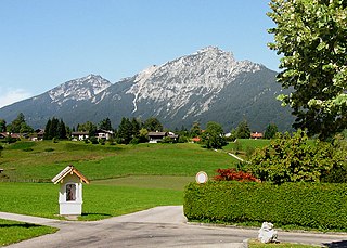
Deutsch: Der Hochstaufen (1771 m) ist der höchste Berg der Staufengruppe und liegt in den Chiemgauer Alpen westlich von Bad Reichenhall in Bayern, Deutschland. Im Bild: Blick von Bayrisch Gmain aus auf den Hochstaufen.
English: Mount Hochstaufen near Bad Reichenhall in Bavaria, Germany. |
| Date | |
| Source | Own work |
| Author | Nikater |
| Permission (Reusing this file) |
Own work, all rights released (Public domain) |
| Camera location | | View this and other nearby images on: OpenStreetMap |
|---|
Licensing[edit]
| I, the copyright holder of this work, release this work into the public domain. This applies worldwide. In some countries this may not be legally possible; if so: I grant anyone the right to use this work for any purpose, without any conditions, unless such conditions are required by law. |
| Annotations | This image is annotated: View the annotations at Commons |
File history
Click on a date/time to view the file as it appeared at that time.
| Date/Time | Thumbnail | Dimensions | User | Comment | |
|---|---|---|---|---|---|
| current | 13:12, 24 July 2011 | | 1,707 × 1,221 (2.05 MB) | Nikater (talk | contribs) | {{Information |Description= {{de| Der Hochstaufen (1771 m) ist der höchste Berg der Staufengruppe und liegt in den Chiemgauer Alpen westlich von Bad Reichenhall in Bayern, Deutschland}} {{en|Mount Hochstaufen near Bad Reichenhall in Bavaria, Germany |
You cannot overwrite this file.
File usage on Commons
There are no pages that use this file.
File usage on other wikis
The following other wikis use this file:
- Usage on hu.wikipedia.org
- Usage on sv.wikipedia.org