File:Beaver rail bridge HAER PA,4-BEAV,1-1 crop.jpg

Original file (3,605 × 1,020 pixels, file size: 1.78 MB, MIME type: image/jpeg)
Captions
Captions
Summary
[edit]| Description |
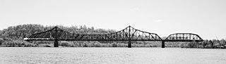
English: Beaver Bridge (Ohio River)
Pittsburgh & Lake Erie Railroad, Ohio River Bridge, Spanning Ohio River, West of Beaver River, Beaver, Beaver, PA: Overview of east elevation, looking SW. Building/structure dates: 1908 initial construction. “The bridge is significant for its relatively long and heavy cantilever truss, planned shortly before the Quebec cantilever bridge collapse of 1907. Rather than select a different design, the railroad proceeded, implementing design checks and strict quality control procedures. Despite a conservative overall design, the bridge includes a number of innovative structural details. The substructure is also significant for its early use of concrete pier caissons.”
|
|||||||||||||||||||||||
| Date | Spring 1999 | |||||||||||||||||||||||
| Source | File:Beaver rail bridge HAER PA,4-BEAV,1-1.png which is from: https://www.loc.gov/pictures/item/PA3716/ → [1] → [2] | |||||||||||||||||||||||
| Author |
|
|||||||||||||||||||||||
.jpg)
![[1]](http://lcweb2.loc.gov/cgi-bin/displayPhoto.pl?path=/pnp/habshaer/pa/pa3700/pa3716/photos&topImages=361923pr.jpg&topLinks=361923pv.jpg,361923pu.tif&title=HAER%20PA,4-BEAV,1-1&displayProfile=0)
| Camera location | | View this and other nearby images on: OpenStreetMap |
|---|
| Object location | | View this and other nearby images on: OpenStreetMap |
|---|
| This is a retouched picture, which means that it has been digitally altered from its original version. Modifications: cropped, color cuver adjusted. The original can be viewed here: Beaver rail bridge HAER PA,4-BEAV,1-1.png:
|
Licensing
[edit]

|
This file comes from the Historic American Buildings Survey (HABS), Historic American Engineering Record (HAER) or Historic American Landscapes Survey (HALS). These are programs of the National Park Service established for the purpose of documenting historic places. Records consist of measured drawings, archival photographs, and written reports.
|
| This image or media file contains material based on a work of a National Park Service employee, created as part of that person's official duties. As a work of the U.S. federal government, such work is in the public domain in the United States. See the NPS website and NPS copyright policy for more information. |
File history
Click on a date/time to view the file as it appeared at that time.
| Date/Time | Thumbnail | Dimensions | User | Comment | |
|---|---|---|---|---|---|
| current | 01:19, 15 December 2010 | 3,605 × 1,020 (1.78 MB) | Saibo (talk | contribs) | color curves adjusted | |
| 01:15, 15 December 2010 | 3,605 × 1,020 (1.72 MB) | Saibo (talk | contribs) | == {{int:filedesc}} == {{Information |Description={{en|Pittsburgh & Lake Erie Railroad, Ohio River Bridge, Spanning Ohio River, West of Beaver River, Beaver, Beaver, PA: Overview of east elevation, looking SW. Building/structure dates: 1908 initial const |
You cannot overwrite this file.
File usage on Commons
The following page uses this file:
File usage on other wikis
The following other wikis use this file:
- Usage on de.wikipedia.org
- Usage on en.wikipedia.org
- Usage on www.wikidata.org