File:BelgieGemeenschappenkaart.svg
Jump to navigation
Jump to search

Size of this PNG preview of this SVG file: 319 × 261 pixels. Other resolutions: 293 × 240 pixels | 587 × 480 pixels | 939 × 768 pixels | 1,252 × 1,024 pixels | 2,503 × 2,048 pixels.
Original file (SVG file, nominally 319 × 261 pixels, file size: 79 KB)
Captions
Captions
Add a one-line explanation of what this file represents
Summary
[edit]| Description |
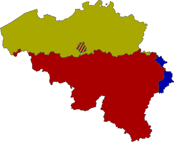
When using {{en:Template:Legend}} or your language's version (see the list under Languages on the English template page's sidebar) in a caption for this image, use the color values: #A0A000 as gold, #A00000 as red, and #0000A0 as blue. English (en): Map of the Communities of Belgium
Gold: Flemish Community (Dutch-speaking Community) Red: French Community
français (fr): Carte de la Belgique avec les communautés
Communauté flamande en or La communauté française en bordeaux la communauté germanophone en bleu
Nederlands (nl): Kaart van België met de Gemeenschappen
Vlaamse Gemeenschap Franse Gemeenschap Duitstalige Gemeenschap
polski (pl): Mapa wspólnot Belgii
Złoty: flamandzka Czerwony: francuska Niebieski: niemieckojęzyczna
|
| Date | |
| Source | Own work |
| Author | Vascer, Knorck |
| Other versions |
|

Licensing
[edit]
I, the copyright holder of this work, hereby publish it under the following license:
This file is licensed under the Creative Commons Attribution-Share Alike 3.0 Unported license.
- You are free:
- to share – to copy, distribute and transmit the work
- to remix – to adapt the work
- Under the following conditions:
- attribution – You must give appropriate credit, provide a link to the license, and indicate if changes were made. You may do so in any reasonable manner, but not in any way that suggests the licensor endorses you or your use.
- share alike – If you remix, transform, or build upon the material, you must distribute your contributions under the same or compatible license as the original.
File history
Click on a date/time to view the file as it appeared at that time.
| Date/Time | Thumbnail | Dimensions | User | Comment | |
|---|---|---|---|---|---|
| current | 13:17, 10 March 2010 | | 319 × 261 (79 KB) | Vascer (talk | contribs) | color match |
| 14:30, 24 May 2009 |  | 319 × 261 (79 KB) | Knorck (talk | contribs) | grmpf - size adj | |
| 14:27, 24 May 2009 |  | 744 × 1,052 (79 KB) | Knorck (talk | contribs) | borders of German-speaking Community rectified | |
| 18:53, 10 October 2008 |  | 307 × 251 (88 KB) | Vascer (talk | contribs) | {{Information |Description={{fr|1=Carte de la Belgique avec la Communauté flamande en or; la communauté française en bordeaux et la communauté germanophone en bleu.}} |Source=Fait moi-même |Author=Moi |Date=~~~~~ |Permission= |other_versions= }} <!- |
You cannot overwrite this file.
File usage on Commons
The following 5 pages use this file:
File usage on other wikis
The following other wikis use this file:
- Usage on af.wikipedia.org
- Usage on ar.wikipedia.org
- Usage on ast.wikipedia.org
- Usage on bn.wikipedia.org
- Usage on br.wikipedia.org
- Usage on ca.wikipedia.org
- Usage on cy.wikipedia.org
- Usage on da.wikipedia.org
- Usage on de.wikipedia.org
- Usage on de.wikibooks.org
- Usage on de.wikinews.org
- Usage on de.wikivoyage.org
- Usage on en.wikipedia.org
- Usage on eo.wikipedia.org
- Usage on es.wikipedia.org
- Usage on eu.wikipedia.org
- Usage on fa.wikipedia.org
- Usage on fi.wikipedia.org
- Usage on frr.wikipedia.org
- Usage on fr.wikipedia.org
View more global usage of this file.