File:Bell's 3rd, 4th, and 5th Addition to the City of Seattle, circa 1890 (MOHAI 13330).jpg
Original file (1,200 × 636 pixels, file size: 116 KB, MIME type: image/jpeg)
Captions
Captions
Summary[edit]
.jpg&action=edit§ion=1)
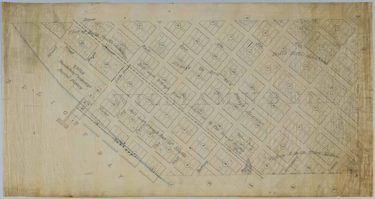
| English: Bell's 3rd, 4th, and 5th Addition to the City of Seattle, circa 1890
( |
||||||||||||||||||||||||
|---|---|---|---|---|---|---|---|---|---|---|---|---|---|---|---|---|---|---|---|---|---|---|---|---|
| Photographer |
English: Anderson, Oliver P. (Oliver Phelps) |
|||||||||||||||||||||||
| Title |
English: Bell's 3rd, 4th, and 5th Addition to the City of Seattle, circa 1890 |
|||||||||||||||||||||||
| Description |
English: William Nathaniel Bell (1817-1887) and his wife, Sarah Ann (Peter) Bell (1819-1856), were members of the pioneering Denny Party, arriving in present-day West Seattle in 1851. The Bells helped to establish the settlement that became Seattle, settling north of the future downtown in "Belltown." Virginia and Olive streets are named for two of Bell's daughters, and Stewart Street honors Olive's husband, Joseph H. Stewart. In 1856 William took an ailing Sarah to California, where she died later that year. William returned to Seattle in 1870, and found that his property had become valuable. He began dealing in real estate and investments, and remained in Seattle with his second wife, Sarah's sister, Lucy (Peter) Gamble (b. 1823), until his death. The plat map pictured here shows William Bell's Third, Fourth, and Fifth Additions to the City of Seattle, part of his original donation claim granted by the U. S. Government. The map is stamped with the name of Oliver P. Anderson, a local an engineer and draughtsman who started his own company in 1890. Caption information source: "Bell, William Nathaniel (1817-1887)," by Junius Rochester, HistoryLink.org Essay 2015.
|
|||||||||||||||||||||||
| Depicted place |
English: United States--Washington (State)--Seattle |
|||||||||||||||||||||||
| Date | circa 1890 | |||||||||||||||||||||||
| Medium |
English: 1 map: color |
|||||||||||||||||||||||
| Dimensions | height: 47.2 in (120 cm); width: 24.5 in (62.2 cm) | |||||||||||||||||||||||
| Collection |
|
|||||||||||||||||||||||
| Current location | ||||||||||||||||||||||||
| Accession number | ||||||||||||||||||||||||
| Source |
English: Museum of History and Industry |
|||||||||||||||||||||||
| Permission (Reusing this file) |
|
|||||||||||||||||||||||
| Credit Line | MOHAI, 2019.3.11 | |||||||||||||||||||||||
File history
Click on a date/time to view the file as it appeared at that time.
| Date/Time | Thumbnail | Dimensions | User | Comment | |
|---|---|---|---|---|---|
| current | 18:12, 2 December 2020 | | 1,200 × 636 (116 KB) | BMacZeroBot (talk | contribs) | Batch upload (Commons:Batch uploading/University of Washington Digital Collections) |
You cannot overwrite this file.
File usage on Commons
The following page uses this file:
.jpg)
.jpg&oldid=820579295)